Friday 31 October 2014

Is this what it takes?

Something quite extraordinary happened this week. Lafarge Tarmac walked into the centre of a media storm, after it submitted Hopwas Woods near Tamworth, 50 hectares of ancient woodland, as a preferred site for sand and gravel quarrying for Staffordshires’s Minerals Local Plan. Local people were furious. A massive response erupted both in traditional and on social media; thousands signed online petitions. Let’s trace just how fast things happened:

Lafarge Tarmac have made an initial representation for Hopwas Wood to be included as a preferred site for future mineral extraction.
The scheme for Hopwas Hayes Wood was not included in the original Minerals Local Plan, which was consulted on earlier this year. But additional site options were then submitted by developers following the first draft and consultation with the public began last Friday.
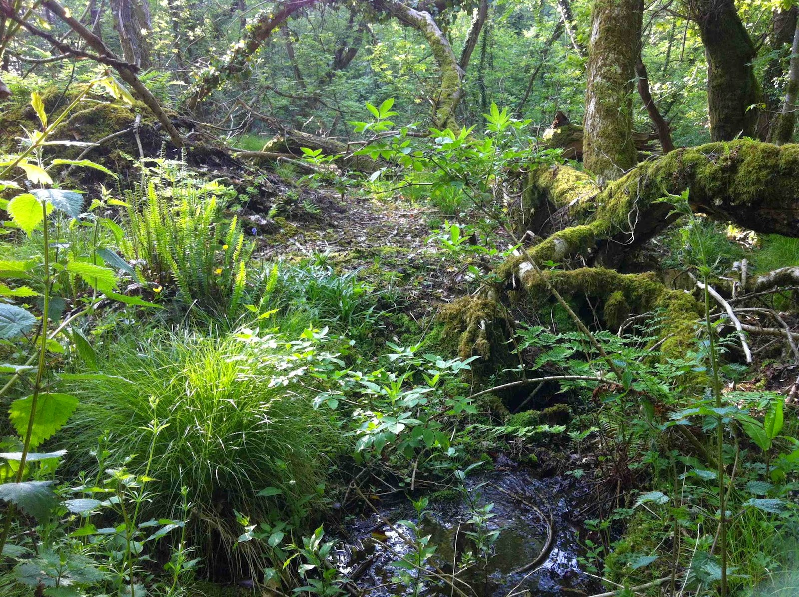
The Woodland Trust has today been informed of the largest threat to a single ancient woodland site in England that the charity has seen in its 42-year history... Lafarge Tarmac is attempting to reap huge profits from the destruction of ancient woodland – an irreplaceable habitat – and we will object to this proposal in the strongest terms.
Ancient woods like Hopwas are nationally important and to destroy them would wipe out hundreds, if not thousands of years’ worth of ecology, history and beauty that can never be replaced.
What we're concerned about is that people are putting profits before the long term importance of the environment for society. 
Following dialogue with stakeholders and partners we have asked Staffordshire County Council to withdraw the Hopwas Woods proposal from the Minerals Local Plan. We pride ourselves on working in harmony with local communities and want to do so at Hopwas.
This is fantastic news for the people of Tamworth and Lichfield that Lafarge Tarmac have seen sense under the weight of public opposition to the plans. We have never seen a reaction like we have had to this story over an industrial plan. Congratulations to everyone who took part in campaigning to save the woods!
You have to ask yourself, what possessed Lafarge Tarmac to put forward such a site? And why they didn’t foresee the negative public response and the possibility of a barrage of damaging publicity? 

Saying that, in the space of a week, Lafarge Tarmac has seen sense. Aggregate Industries, on the other hand, has not. Are we in Ottery St Mary not shouting loud enough? Or is Lafarge Tarmac better at listening to local concerns than AI? If anyone needs reminding why Straitgate Farm should not be a preferred site in Devon’s Minerals Local Plan - see the post below. 

Ottery St Mary's ancient woodland at Cadhay Bog at risk from Aggregate Industries' plans

Multiple impacts

NPPF: "When determining planning applications, local planning authorities should: ensure, in granting planning permission for mineral development, that there are no unacceptable adverse impacts on the natural and historic environment, human health or aviation safety, and take into account the cumulative effect of multiple impacts from individual sites…" [144]

Multiple impacts? Like these, for Aggregate Industries' plans for Straitgate Farm?

impact on drinking water supplies to 100 people and Environment Agency’s SPZ
impact on water supplies to 3 farms and surrounding agricultural land
impact on stream flows to wetland habitats in ancient woodland
impact on birdstrike risk to Exeter Airport from ponding
impact on archaeological remains of an Iron Age settlement 
impact on dormice - a European Protected Species - and their habitat
impact from the loss of c.80 acres of the 'best and most versatile' agricultural land
impact from the loss of almost 2 miles of ancient hedgerows with high biodiversity value
impact on veteran oaks
impact on the view from East Devon AONB
impact on surface water run-off and flooding to communities downstream
impact on grade I listed Cadhay’s mediaeval fish ponds
impact on grade II listed Straitgate Farmhouse and its setting
impact on public roads from hauling as-dug material to process off-site
impact on the health and well-being of local people from hgvs, noise and dust 
impact on tourism and commercial interests of Ottery St Mary
impact on restoration plans for Woodbury Common should processing continue at Blackhill

Straitgate Farm – the ‘best and most versatile agricultural land’

All the land threatened at Straitgate Farm, around 80 acres, is graded under the Agricultural Land Classification as 3a, and is therefore considered the "best and most versatile agricultural land".

In 1968, the Ministry of Agriculture Fisheries and Food strongly objected to plans advanced at that time to quarry Straitgate:
The Minister is anxious to safeguard such valuable agricultural land so far as possible and I am directed to advise that in his opinion there is the strongest possible objection to the proposed development on agricultural grounds.
The application also gives every indication of being "the thin end of the wedge", and if approval were to be granted others adjoining or nearby would almost certainly be precipitated, with the greatly increased loss of further good agricultural land.
How this important natural resource is used is vital to sustainable development. This includes taking the right decisions about protecting it from inappropriate development. 
Planning authorities... should take into account the economic and other benefits of the best and most versatile agricultural land. Where significant development of agricultural land is demonstrated to be necessary, local planning authorities should seek to use areas of poorer quality land in preference to that of higher quality. 
Consultations with Natural England are required on all applications for mineral working or waste disposal if the proposed afteruse is for agriculture or where the loss of best and most versatile agricultural land agricultural land will be 20 ha or more.
Standing in one of the fields at Straitgate looking over the farm buildings towards Sidmouth Gap and East Devon AONB

Tuesday 28 October 2014

‘Historic Environment Good Practice Advice in Planning’ – the MPA is not happy

The Mineral Products Association - the trade body representing quarry companies - is not happy with English Heritage. The MPA claims English Heritage’s draft Good Practice Advice (GPA) - a series of documents intended to help local authorities, applicants and other interested parties implement the historic environment policy of the National Planning Policy Framework (NPPF) - is "not in tune with the presumption in favour of sustainable development formalised by the NPPF". Its director of planning said:
It seems that English Heritage expects the planning system to protect heritage assets above all other interests and that is not how the planning system is supposed to be operating.
It is bothered that the previous advice "Mineral Extraction and Archaeology: A Practice Guide" - a document produced in 2008 by the Minerals and Historic Environment Forum (MHEF) - has been sidelined, "given only one brief mention in the draft GPA":
In complete contrast to the MHEF, the group that drafted the GPA was comprised almost entirely of heritage professionals. Unless English Heritage involves a broader range of interested parties in the production of the GPA, with a view to winning their joint endorsement to the final document, it seems unlikely that the planning system will afford much weight to what it says. That is also likely to result in a document that reflects a better balance of interests…
In other words, the MPA wants planning advice that better reflects the interests of its quarrying members, and that less reflects the interests of the UK's historic environment. The MPA champions the NPPF’s "presumption in favour of sustainable development", but that's the same document that says local planning authorities "should recognise that heritage assets are an irreplaceable resource [to be conserved] in a manner appropriate to their significance".

But what is in the draft GPA that has made the MPA so angry? Well, and bearing in mind we now have evidence of a settlement of Iron Age roundhouses at Straitgate, here are a few things that English Heritage, a statutory consultee in the planning process, says:

Note 1: The Historic Environment in Local Plans

On Local Plan site allocations - "The best way of ensuring that the selection of sites to be put forward for development supports the delivery of the conservation strategy within the Local Plan is to avoid the selection of sites that will harm the significance of heritage assets." [16]

Note 2: Decision‐Taking in the Historic Environment

On Archaeological and historic interest - "Archaeological interest, as defined in the NPPF, differs from historic interest… because it is the prospects for a future expert archaeological investigation to reveal more about our past that need protecting." [13]

On Assessing the proposals - "Heritage conservation is an objective of sustainable development, as are many other public benefits. The optimum sustainable scheme is therefore one that can clearly show that it avoids, minimises or mitigates conflict between heritage conservation and any other public benefits it may deliver. This may be achieved, for example, by reconsidering the means of providing the public service or benefit, the location or the design." [23] "For loss to be necessary there will be no other reasonable means of delivering similar benefits, e.g. a different design, other mitigation or, as a last resort, development of an appropriate alternative site." [24]

On Decision‐taking for assets with archaeological interest - "For sites with archaeological interest, whether designated or not, the benefits of conserving them are a material consideration when considering planning applications for development." [31]

On Recording and furthering understanding - "…records cannot deliver the sensory experience and understanding of context provided by the original heritage asset, so the ability to investigate and record a heritage asset is not a factor in deciding whether consent for its destruction should be given." [32]

On Public engagement - and remember all the initial hoo-ha and secrecy surrounding the archaeology at Straitgate in September? - "Where appropriate and possible, local planning authorities and the developer are advised to consider the benefits of making the investigative works open to and interpreted for the public and to include that as part of the written scheme of investigation. The results can contribute to a deeper sense of place, ownership and community identity. Promoting understanding will increase active protection for the historic environment. Opportunities for public engagement, proportionate to the significance of the investigation, could, for example, include enabling participation in investigation, providing viewing platforms and interpretation panels, jointly designed open days in partnership with the local community, public talks and online forums as well as coverage in local media." [45]

On Unexpected discoveries during work: "Where a new heritage asset is discovered or an existing known asset proves to be more significant than foreseen at the time of application, the local planning authority is advised to work with the developer to seek a proportionate solution that protects the significance of the new discovery, so far as is practical, within the existing scheme. Developers are advised to incorporate the potential for unexpected discoveries into their risk‐management strategies." [46]

So you can see why the MPA is concerned. It's not going to be in favour of anything - even something as important as the nation's historical and archaeological assets - that hinders the activities and profits of its multinational cement conglomerate backers. English Heritage's GPA is something for us all, including DCC, to bear in mind, as Aggregate Industries pushes on with its plans to bulldoze Straitgate Farm.

Nick Smith

Tuesday 21 October 2014

Dust impact on observatory stops quarry extension

Mhardcastle
Dust and noise - two of the main impacts people think of in relation to quarrying. And while noise is a nuisance, dust can be a killer.

Small particles are a particular problem. They can travel large distances and can be damaging to human health even in low concentrations over prolonged periods of time. Terms PM10 and PM2.5 are used to describe particulate matter of 10μm and 2.5μm in size respectively (a human hair is about 50μm in diameter). A quarry can generate significant amounts of this harmful dust over its lifetime, particularly during dry conditions. We’ve written about this dust - Respirable Crystalline Silica - before. HSE advice is that "all RCS is hazardous", and that workers should be told that "very fine quarry dust can cause silicosis, which leads to disablement and early death". The US Health Department warns "Residents near quarries and sand and gravel operations potentially are exposed to respirable crystalline silica". One study concludes "there seems to be a risk also in groups exposed to lower levels [of respirable quartz]. There is no consensus how low an acceptable risk level ought to be".

Keeping these facts in mind, it’s interesting to note that plans for a sand and gravel quarry extension in Hertfordshire were recently refused on appeal - because of this PM2.5-PM10 dust. Perversely, and despite objectors' fears, not because the planning inspector was concerned about the impact of prolonged exposure to this airborne carcinogenic dust on people living as close as 75m away, but because he was concerned about the impact the dust might have on an observatory - 550m away.

The quarry company had put forward a Dust and Air Quality Management Plan (DMP) which claimed to “proactively” manage the dust. Objectors, however, had little confidence in these measures, and nor did the University of Hertfordshire’s Bayfordbury Observatory, who were "...concerned about the potential for a significant loading in PM dust in the air for significant periods of time".

The Inspector was also unconvinced the DMP would work:
I am also concerned about its effectiveness in limiting harmful concentrations of PM2.5-PM10 dust, given their long suspension in the air and ensuing unpredictability and that monitoring and any preventative action would need to be the subject of constant surveillance... Responding to visible signs of dust emissions in dry, windy conditions would plainly not be effective as a preventative measure… For all that the DMP would provide for an enhanced level of control over dust emissions, given the risks and uncertainties that I have outlined above, I cannot be confident that it would prove to be fully effective... I conclude that the proposal would give rise to an unacceptable risk of harm to the operation of research equipment at the observatory, having regard to dust.
But when the planning inspector recognised the "long suspension in the air and ensuing unpredictability” of PM2.5-PM10 dust, and the harm such dust might cause an observatory 550m away, why did he not think that over prolonged periods it might be harmful to people too, living just 75m away? Were his hands tied by planning guidance? Did he put too much faith in consultants' reports? The observatory may have been particularly sensitive to dust, but so too are children, asthmatics, allergy sufferers and the elderly.

Whatever his reason, he refused the appeal anyway, and people nearby were spared prolonged and elevated dust emissions; others across the country continue to suffer. 

Since PM2.5-PM10 dust can travel long distances, planning authorities should be pushing quarry companies to act in a more precautionary manner, pushing for greater stand-offs from nearby communities, pushing for more rigorous dust mitigation. As DCC's Sustainability Appraisal warns, "due to a changing climate there is the potential for the impact of noise and dust on sensitive receptors to become more intense. Hotter summers will provide conditions that will produce additional dust, and people will spend more time outdoors and leave the windows of dwellings and workplaces open for longer". Planners' attitude to dust and the harm it can cause has to change.


PS. On the subject of consultants' reports, prepared for and paid for by quarry companies, and how much trust can be placed upon them, it may come as no surprise that the Dust Impact Assessment for the above quarry extension claimed "any impact associated with dust generation upon the observatory is considered to be low". The Planning Inspector, on the other hand, said "given the apparent importance attached to the observatory’s research activities, any harm arising from operations, notably in relation to PM10 dust, must, I conclude, have the potential to be severe". Low or severe? They can't both be right.

Thursday 16 October 2014

Update

Archaeological work at Straitgate Farm is ongoing. Further investigation in the areas showing evidence of Iron Age huts has however been on hold - the trenches are full of water. There appears to be a tail-off in archaeological evidence moving further away from the Iron Age settlement, but a few new prehistoric features are being uncovered that had not shown up in the geophysical survey. No evidence has so far been found of the prehistoric boundary running through the site, but this would have to be explored further should planning permission eventually be granted.

Consultants AMEC have just uploaded another round of groundwater measurements from the 11 boreholes around the site, and now have a full 12 months of data from all of the boreholes. AMEC will continue to monitor groundwater levels, and will be producing a report for AI in the new year. They have also sampled water from three boreholes and three springs to test water quality, and continue to take regular stream flow measurements.

Miscellaneous


Part of AI's undoing, according to The Secretary of State, was:
There is little evidence that thought has gone into alternative layouts and arrangements of structures to take account of the site’s environmental constraints or wider context. Indeed, there is little identification of these, or opportunities, unlike the analysis carried out for the Objectors... [12.36]
A warning that environmental constraints for any application must be properly addressed, even by AI.


In an article in Mineral Planning, on the effects of the NPPF, the director of planning for the Mineral Products Association admits:
Operators have been eking out reserves they already have. The last thing they have wanted is to go anywhere near a planning authority... [as a result] MPA survey figures suggest both producers and consumers have adapted by switching from sand and gravel to crushed rock.
On the subject of planning, he bemoans that:
Concern over vulnerability to legal challenge is leading to an ever more precautionary approach by regulators. This results in delay and unnecessary costs in providing superfluous information to support plan allocations and planning applications.
Superfluous information? Is that really the industry's thinking when responding to its impact on people, groundwater, ecology, history, endangered species, dust, noise, traffic, etc?


An article by Environmental Working Group claims that thousands in the US are exposed to potential health risks from silica sand mining:
Research has shown that these particles can degrade air quality as far as 750 meters away, leading to a variety of serious health problems, particularly in children and other vulnerable populations.
Dust, and its effects upon health, is a continuing concern around quarry sites in the UK; we have written a number of times in the past about Respirable Crystalline Silica.

4. Business and society: defining the 'social licence'

An article by John Morrison in The Guardian argues that:
Social licence can never be self-awarded, it requires that an activity enjoys sufficient trust and legitimacy, and has the consent of those affected. Business cannot determine how much prevention or mitigation it should engage in to meet environmental or social risk – stakeholders and rights-holders have to be involved for thresholds of due diligence to be legitimate (sometimes even if these are clearly determined in law).

A blog on the impacts of mining across the world, by a PhD candidate at the University of Bristol, tackles the subject of corporate social responsibility or CSR:
Often, CSR in the mining industry is little more than a public relations exercise, with no tangible reality to support its elaborate rhetoric.
6. Prehistoric boundary

For anybody interested in learning about Prehistoric Boundaries - like the one thought to run through Straitgate Farm - this English Heritage document explains more.

Friday 10 October 2014

The cumulative effect

Let’s summarise what’s happened since 2012, when DCC decided that Straitgate was the best of 10 sites in East Devon to put forward as a Preferred Site for sand and gravel in its new Minerals Plan.

In 2011/12, DCC performed a "detailed appraisal" of each of the 10 sites to find those with "the least constraints and most likelihood of potential delivery". It found issues with all of them - but apparently Straitgate (S7) was the only site without a ‘showstopper’; of course, it was also the only site owned by Aggregate Industries. DCC's belated Sustainability Appraisal - a process which did not inform the rejection of the alternative sites as it should have - found even more constraints. In fact, Straitgate had more "significant negative impacts” than almost any other site; the Environment Agency remarked "It is apparent from the SA that some of the excluded sites may [be] preferable in environmental terms".

Since DCC’s original appraisals, Straitgate’s list of issues has only grown. We now know that:

Natural England, the Environment Agency and Exeter Airport all have unresolved concerns;


Cadhay Bog, with its ancient woodland and wetland habitats, is now recognised in all likelihood to have been wooded for up to 10,000 years, being a remnant of the 'wildwood' that colonised Britain after the last Ice Age. According to SLR, AI’s consultants, Cadhay Bog is “in very good condition” with "significant biodiversity interest” and "the ecological site most at risk from the proposals”;

Straitgate has a population of dormice - a European Protected Species; AI will need to convince Natural England that a quarry and the removal of almost 2 miles of ancient hedgerow dormouse habitat is "preserving public health or public safety or other imperative reasons of overriding public interest including those of a social or economic nature and beneficial consequences of primary importance for the environment”, has “no satisfactory alternative” and “will not be detrimental to the maintenance of the population of the species concerned at a favourable conservation status in their natural range”;

And now, the fields at Straitgate are also revealing signs of Iron Age settlement that will probably require a very full archaeological excavation before any quarry could ever take place.

Any of these new developments might have been considered ‘showstoppers' in their own right, but when you combine them all, and then add them to the ones we knew about before - 100 people and 3 farms relying on the site for drinking water, increased birdstrike risk to aircraft from ponding, visual impact on AONB, flooding, effect on Grade I & II listed buildings, off-site processing using public not internal haul roads - then the cumulative effect of any quarrying makes Straitgate look a non-starter. Sometimes you wonder whether DCC couldn't have picked a more constrained site if it had tried.

Of course, if DCC does go forward with Straitgate as its preferred choice, it will somehow have to persuade a public inspector of the soundness of relying on a site with potentially as little as 6 years, or less, of sand and gravel... and a list of issues as long as your arm.

Friday 3 October 2014

Settlement of Iron Age roundhouses at Straitgate?

Evidence of a prehistoric settlement of Iron Age roundhouses from over 2000 years ago was one of the last things Aggregate Industries would have wanted to find from its archaeological surveys at Straitgate.

Michael Murray
The Devon Historic Environment Records for the area, kindly sent to us back in 2012, had suggested there might be - based on an excavation in 1996-7 next to Straitgate Farm, referred to as the 'Long Range excavation'. This archaeological dig was one of the eight site excavations undertaken in advance of the new A30 between Honiton and Exeter, and revealed the presence of Iron Age roundhouses and pottery from around 400-100 BC, as well as finds from the early Neolithic period. Two of the roundhouses were indicated by evidence of complete penannular gullies - circular-shaped gullies formed either by rainwater dripping off the end of the eaves and eroding a small trench or where a drainage trench has been cut to carry rainwater away from the walls. These are documented fully in Prehistoric & Roman Sites in East Devon: The A30 Honiton to Exeter Improvement DBFO, 1996-9 (Wessex archaeology report).

Many more of these structures are thought to lie in the fields at Straitgate, after the geophysical survey last year revealed 10 or more circular or part-circular anomalies. Investigations at Straitgate will add to the 'Long Range' data, and will give a fuller picture of what life was like for our predecessors - in a hill-top settlement overlooking where Ottery St Mary stands today.

Archaeology is rarely a ‘showstopper’ - many think Straitgate already has plenty of those. But as part of Devon’s history, Straitgate's past will have to be fully explored and documented before any of it is lost to a Swiss multinational cement conglomerate.


For maps of the historic finds in the area, contact Devon County Council Historic Environment Team.

Wednesday 1 October 2014

Archaeology at Straitgate


A group of local people met with archaeological contractors and DCC archaeologists on the fields at Straitgate Farm yesterday. AI and its consultants, SLR, were also present.

The archaeologists from DCC and the archaeological contractors spoke enthusiastically about a landscape that has been extensively occupied and farmed on and off over thousands of years. Signs from a number of prehistoric dwellings have been revealed, from the Iron Age to as far back, possibly, as the Neolithic period. Finds so far include pottery, post holes, drip gullies and enclosure boundaries. There is more archaeology than many had expected, and AI could eventually be called upon to excavate, survey and record much larger areas - if it were to ever secure planning permission.

Such evaluations would further add to AI’s running bill of costs. With so many constraints already identified, sand and gravel from Straitgate is unlikely ever to be won cheaply.