Showing posts with label AMEC/AFW/Wood. Show all posts

Tuesday, 27 July 2021

AI’s changing story on infiltration rates leads to ANOTHER flood mitigation issue

According to this article from South Africa, groundwater is "the saviour we need to take care of":

Dr Lukas says because groundwater is something that cannot be seen by the naked eye, the general public has many misconceptions about groundwater. Some people think that you can drill a hole just anywhere and that you will find water, others believe that water flows in underground rivers. It generally moves very slowly, only a few meters per year. 
A few metres per year is what Professor Brassington says too, for the geology underlying Straitgate Farm, in the unsaturated zone, the zone above the water table, the zone into which the flood mitigation trenches would be dug: 
According to Wang et al (2012) the unsaturated zone velocity for the Sherwood Sandstone Group falls in the range 0.6 – 2.3 m/year with a mean of 1.06 m/year
This is all about the hydraulic conductivity. As Professor Brassington explains, hydraulic conductivity is: 
A measure of the rate that water can flow through an aquifer. Often taken to mean permeability with respect to water. The term normally is applied to saturated hydraulic conductivity. Unsaturated hydraulic conductivity has a smaller value and applies only to the unsaturated zone.
The rate at which water infiltrates into the soil, into the unsaturated or vadose zone, is dependent upon the hydraulic conductivity
Hydraulic conductivity is a property of the soil, whether it is the (highly varying) hydraulic conductivity in the unsaturated zone or the saturated hydraulic conductivity in the saturated zone. The infiltration rate generally is a flux which depends on the hydraulic conductivity, but also on other variables and parameters such as the wetness of the soil, land use/ land cover, slope, crust formation etc.. Water movement in the vadose zone also is dependent on the hydraulic conductivity and linked to the infiltration rate, but not the same. The infiltration rate is the inflow into the soil, where the water movement in the vadose zone is the flow inside the soil.
Away from the real world, however, Aggregate Industries’ consultants have come up with an alternative story for how water moves through the unsaturated ground – a story that conveniently keeps changing. 

In 2015 and 2017, this was the story being spun: 
recharge to the BSPB (as present at Straitgate) is best represented as a single quick release number, independent of unsaturated depth because conceptually of its more fractured nature etc.
recharge reaches the water table in the BSPB through unsaturated thicknesses of between approximately 3 and 10 m within between 1 and 3 days. 2.7.3
Infiltration tests were attempted. Infiltration rates couldn't be calculated given the "Insufficient drop in water level", but "a permeability in the order of 0.25 to 0.30 m/d" was indicated in the BSPB, and "a permeability in the order of 0.60 to 0.90 m/d" was suggested in disturbed material. The answers were not what the consultants were looking for, so they ignored them: 
the results of these infiltration tests results were not applied, and a value of 1m/d was used instead. This is still a precautionary approach, since recorded recharge rates in the BSPB deposit are in the order of 3 m/d to 9 m/d... as evidenced by the ongoing groundwater level monitoring. 2.10.6 
Then Professor Brassington became involved, and Aggregate Industries' story changed:
Linking rainfall events with changes in groundwater level is not an attempt to prove that the rainfall has reached the water table rapidly (although there is some evidence from hydrographs on site that suggest this happens) 
And the story changed further in May this year: 
Although their methodologies are not necessarily widely recognized, the AFW infiltration tests contribute to a substantial body of evidence that water moves through the unsaturated zone at a relatively quick rate (in the order of at least 0.1 – 0.5 m/d), meaning that travel through the unsaturated zone is measured in days/weeks rather than years. 
So, Aggregate Industries' consultants have moved from "3 m/d to 9 m/d" to "0.1 – 0.5 m/d".

Flood mitigation capacities were, however, calculated on the basis of 1 m/d:
Infiltration rates of 1m/d (0.0416 m/hr) were applied to the infiltration ditches/ponds based on robust and extensive hydrogeological assessments... 

If the company’s hydrology consultants are now talking about "0.1m/d" – a 10th of what was initially assumed – then obviously another major problem can be added to the list. 

Thursday, 15 July 2021

AI’s consultants ‘not coherent on hydrogeology’ – warns Professor, in new response

Professor Brassington – in reply to Wood’s follow-up notes after the meeting with the Environment Agency and others – has produced the following response in relation to Aggregate Industries’ proposal to quarry Straitgate Farm. His report begins: 
In my view the most significant aspect of the proposal by Aggregate Industries is the removal of the unsaturated zone over the area of the Straitgate Farm that is proposed to form the new quarry. In my opinion there is no doubt whatsoever that the water which percolates through this area will, once the unsaturated zone has been substantially removed have lost a significant exposure between the percolating water and the surrounding rock. Inevitably, this will mean that the rock/water interactions will have been reduced substantially which in turn can only result in the pH of the percolating waters being reduced and so the acidity of the spring waters will increase.
He also writes: 
I fail to see how Wood can come to their conclusion that the recharging water gets through the unsaturated zone in at the most a few days. All my experience of working on the Sherwood Sandstone aquifer has shown that where the rock is poorly cemented and therefore does not have any significant fractures, the rate of downwards flow is a metre or two a year. The references I have read confirm this view that I have discussed in a note dated 17th May 2021 and submitted to Devon CC. A summary of work carried out by numerous authors is given by Ascott et al (2016) that refers to an earlier paper by Chiltern and Foster (1991). The following table from Wang et al (2009) summarizes the general view of the British hydrogeological community on the downwards migration rates including those that apply to the Sherwood Sandstone.
And in summary: 
The arguments put forward by Wood do not present a coherent picture of the hydrogeology of the site. They appear not to understand the way that flow through the unsaturated zone works and that the moisture content of the rock defines its hydraulic conductivity. They draw conclusions from the data, such as on the hydraulic conductivity from the leach testing which are not valid as the tests do not provide data and they ignore Aggregate Industries data such as the grain-size analysis that shows that the fine particles in the rock will have a significant impact on reducing the hydraulic conductivity. 

Wood also misinterprets my statements about the impact of removing the unsaturated zone on the water quality to infer that I am against all quarrying while my arguments relate to this site only. They ignore the published data on flow velocities in the unsaturated zone and without carrying out any tests of their own conclude that the flow rates through the unsaturated zone at Straitgate are very much higher than is possible. They now appear to concede that piston flow takes place although they infer that fracture flow dominates water movement through the unsaturated zone. They interpret the relationship between rainfall events and rises in the water table as supporting their views on groundwater flow that ignore the simpler interpretation of it resulting from piston flow. 

In my view, Devon CC should not allow a proposal that will significantly reduce the pH of the drinking water supplies for about 100 local residents in the area around the proposed quarry site and I ask them to refuse the application.

Monday, 28 June 2021

AI’s water consultants pay fines following corruption probe

Following a Serious Fraud Office investigation into Amec Foster Wheeler in 2017 – previously posted about here and here – today it has been announced that: 
John Wood Group PLC ('Wood') today announces that agreements have been reached with the Serious Fraud Office ('SFO') in the UK, the Department of Justice ('DOJ') and Securities and Exchange Commission ('SEC') in the US, and the Ministério Público Federal ('MPF'), the Comptroller General's Office ('CGU') and the Solicitor General ('AGU') in Brazil, to resolve their respective bribery and corruption investigations into the past use of third parties in the legacy Amec Foster Wheeler business.    

Under the terms of the agreements, the Company will pay compensation, disgorgement and prejudgment interest, fines and penalties totalling $177m... 
Wood Group’s payment is one of the largest ever obtained in a UK-led bribery and corruption case. 

Friday, 25 June 2021

AI’s MWWT ‘adjustment’ has been fudged

Aggregate Industries' model of the maximum winter water table – the MWWT, denoted by the contours below – would define the base of any quarry at Straitgate Farm.


Professor Brassington says it can’t be trusted. We have already shown that the MWWT is nothing more than a hand-drawn guesstimate. The MWWT makes no allowance for errors, no allowance for climate change, no allowance for an unorthodox working scheme not used anywhere else. It may give the illusion of being precise, but time has demonstrated it is anything but. 

To indicate this, let's show what journey these contours have been on. Let's superimpose Aggregate Industries' first stab at estimating groundwater levels in 2013 over the latest MWWT. 

In places, the latest MWWT – in blue – is now 5m higher than that initial 2013 estimate. How very fortunate that estimate wasn’t used. The next guesstimate in 2015 was based on levels which we were told "are likely to reflect the highest groundwater levels that may occur at Straitgate". These levels have since been exceeded in numerous locations on numerous occasions. As we recently posted
The maximum water level in PZ2017/02, which exceeded the MWWT back in 2018, went nearly 50cm higher in 2020. The groundwater level in this location has now exceeded the company's original guess by a whopping 1.75m. Water levels in PZ06 – installed back in 2013 – also reached a new maximum, as did three other piezometers. 
In time, the MWWT will be exceeded again. A maximum is not a maximum if it keeps being exceeded. 

The latest MWWT is found in the recently submitted document Collation of post Regulation 22 discussions and clarifications, which says: 
...as requested by DCC, this document includes a revised version of the Maximum Winter Water Table (MWWT) grid which incorporates any recently recorded groundwater water levels higher than the previous MMWT (including ‘spot’ groundwater level measurements recorded in 1990).
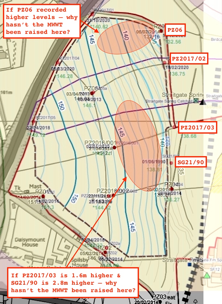
The revised MWWT is included in this pack of correspondence and includes additional adjustment for slightly higher groundwater levels recorded close to the eastern boundary (PZ06, 2017/02 and 2017/03) in April 2018 and February 2020. The following are noted from the revised MWWT: The method used for determining the MWWT is slightly conservative and means that the extent to which the grid is raised propagates from the eastern boundary to the centre of the excavation area. In reality, the higher recorded groundwater levels most likely represent more localized effects close to the eastern boundary.
But knowing these contours are drawn by hand – a potentially biased and persuadable hand, not some clever computer algorithm – let's look at the revised MWWT against the previous version. Let’s see what allowance Aggregate Industries’ consultants have made for the elevated water levels recorded on the eastern boundary. Superimposing the new MWWT over the previous MWWT – blue for new, grey for previous – this is what we find: 

It's immediately clear "that the extent to which the grid is raised" is minor. 

It's also clear that, far from being "slightly conservative", the MWWT should in fact be raised more widely – given the elevated levels recorded at PZ06, PZ2017/02, PZ2017/03 and SG21/90, given that the MWWT is an interpolated surface, and given the lack of any other contradictory data in the vicinity of these piezometers to demonstrate otherwise. The Environment Agency's proposed conditions state:
If any of the maximum recorded groundwater levels exceed the height of the MWWT grid then the MWWT grid shall be updated using that data... 
Continuous (daily) monitoring of all site piezometers, and interpolation between them, shall be used...  
Our emphasis. So – in the areas indicated – what's happened to the interpolation? In fact, why was the entire MWWT not re-interpolated, in the same way it would have been had all these new maximums been available in 2015? Why have we instead been left with a tweak, an "adjustment", a fudge?

Note that when Aggregate Industries’ consultants talk about "slightly higher groundwater levels" we’re talking about 1.6m in one location, 1.75m in another and 2.8m in another – so not slightly at all. 

Note that when Aggregate Industries’ consultants talk about "most likely more localized effects close to the eastern boundary", they don’t have a watery clue – given the lack of other boreholes between the eastern boundary and the centre of the site. 

So, why has the MWWT not been raised more extensively, based on all the data, based on reason and logic? Easy. These consultants are trying to wrestle from the ground as much material as possible for their paymasters – irrespective of the permanent harm it would cause to surrounding water supplies.

Monday, 14 June 2021

Oh look, yet ANOTHER location where AI’s seasonal working scheme can’t work

Crikey, everywhere you look you find problems with this planning application.

Aggregate Industries' unorthodox untried unproven seasonal working scheme to quarry Straitgate relies on groundwater levels falling by at least 1 metre during the summer months to allow extraction down to the maximum winter water table – the MWWT. Aggregate Industries’ Regulation 22 document claims: 
2.2.8 By working only to the MWWT then during the summer months the water table will be lower. Therefore across the areas being worked the zone of water level fluctuation is undisturbed. This zone is at least 1m thick. Appendix C includes a plot showing the contours of average summer unsaturated mineral thickness, derived from the MWWT (i.e. the final proposed depth of working) and the Average Summer Low Water Table from piezometer readings.
There’s one big mistake right there. Because contours of "average summer unsaturated mineral thickness" will not be generated by using average summer lows. That only shows – in Aggregate Industries' favour of course – the average summer maximum unsaturated thickness. Those dependent on drinking water from the site should instead be concerned about the minimum unsaturated thickness below the MWWT in summer, which can only be derived using maximum summer groundwater levels. You can guess why Aggregate Industries didn’t do that. 

In fact, only by using maximum summer groundwater levels would the ability to reliably comply with planning conditions be demonstrated, knowing that groundwater levels can rise by up to "1m in 5 days", and given that the Environment Agency states:
our recommended condition requires that the base of the excavation is no closer to groundwater level than 1m at any time.
But this post is about more than that. 

We have in the past pointed out that AI's seasonal working scheme for Straitgate can't work as described, that groundwater levels do not fall by 1m around the piezometer location PZ05, a fact that Aggregate Industries recently tried to bury. Groundwater levels do not fall by more than 1m at PZ01 either, but the company argues that at the extraction boundary this would conveniently increase to 1.17m. It’s an absurd claim; Aggregate Industries can’t make predictions to the nearest metre, let alone the nearest centimetre. 


But now, lo and behold, another location has come to light where Aggregate Industries’ seasonal working scheme can’t work. 

The Environment Agency, after a protracted struggle – both by Professor Brassington and us, posted here, here and here – finally accepted that groundwater levels recorded in 1990 should, together with other borehole data, be used to define the MWWT. This was reflected in the Environment Agency’s revised conditions and Position Statement which reads: 
Based on further information received from SAG we recommended to Devon County Council that the applicant updates the Maximum Winter Water Table grid with groundwater levels recorded at the site in 1990. 
Aggregate Industries’ consultants subsequently produced a revised MWWT to accommodate groundwater levels recorded in borehole SG21/90 (also known as SG1990/021). 

But crucially, those 1990 groundwater levels were recorded in summer. The MWWT at location SG21/90 therefore now reflects a summer level. The MWWT and the summer level at SG21/90 are one and the same; the difference is ZERO. Clearly, groundwater levels do not fall by 1m from the MWWT here in the summer. Only by adding 1m to the MWWT in this area could Aggregate Industries' seasonal scheme even begin to work as described.

Appendix C – referred to above, shown below – and its Himalayan-style contours "of average summer unsaturated mineral thickness" is one of the documents Aggregate Industries is relying upon for its planning application.

  
We have already posted that it contains errors the height of houses. That was before the Environment Agency recommended the MWWT be updated using 1990 data. What that means is that around SG21/90 there is not 4m of summer unsaturated thickness as shown above, and here, there is in fact ZERO.

Given that those lines of fiction were interpolated, this figure will obviously have a knock-on effect on the surrounding area, and on the amount of resource available. Obviously, extraction down to the MWWT would never be possible – if planning conditions were complied with – in areas where the groundwater does not fall by 1m in summer.

Lines of fiction? Not only were those amazing patterns derived from just a handful of data points, but in some areas those claimed "contours of average summer unsaturated mineral thickness" even exceed the depth of mineral between the MWWT and underlying mudstone. Sense-checking is not Aggregate Industries' strongest suit.

But it doesn’t stop there, because those Himalayan contours above were generated in July 2017. At that time, only 8 piezometers had been recording groundwater levels for longer than 12 months. The above contours have therefore NOT been updated by the summer groundwater levels recorded over the almost 4 years since then – not just from those 8 piezometers, but also from piezometers PZ2017/01, PZ2017/02, PZ2017/03, PZ2017/04 and PZ2017/05 installed in 2017. 

Neither have those contours been updated using the summer 1990 levels. 

Without using ALL the available summer groundwater data for the site, without using maximum summer groundwater levels, no-one can know what might be revealed, no-one can make an informed decision. 

As things stand, therefore, the Environment Agency's condition could not be met: there would not always be 1m or more of unsaturated material below the level where Aggregate Industries would be working. It's yet another fail.

Wednesday, 2 June 2021

Fracture flow? What fracture flow?


Straitgate Farm is underlain by the Budleigh Salterton Pebble Beds deposit, now called the Chester Formation, part of the Sherwood Sandstone aquifer. The deposit can be seen in the cliffs at Budleigh Salterton – as shown above, below and here.


Aggregate Industries and consultants Wood, previously Amec Foster Wheeler, maintain – as we have previously posted – that at Straitgate:  
...recharge reaches the water table in the BSPB through unsaturated thicknesses of between approximately 3 and 10 m within between 1 and 3 days. 
However, there was a time when Aggregate Industries was arguing the reverse – when the debate was about the risk of importing nutrient-laden soils to Woodbury Common. The company was claiming the soils at Straitgate Farm were "slowly permeable and at times poorly drained": 
This would strongly inhibit the movement of any nutrients added to the surface, either as artificial fertilisers or manure, through the soil profile and into the deeper overburden and mineral resource that would be exported off site for processing. 
This is still in fact echoed in the soils report which also talks about "slowly permeable subsoils". The infiltration tests also found that the undisturbed material "did not show any measurable ability to soakaway". At that time, it wasn’t the answer Aggregate Industries was looking for, and so the company concluded – surprise, surprise – that "these results cannot be considered to be representative of the site as a whole." 

Water speeding through the unsaturated zone "within between 1 and 3 days" is in contradiction with what the textbooks say. Professor Brassington explains how movement of water through the unsaturated zone at Straitgate takes years, and that the loss of this unsaturated zone would make water permanently more acidic for all those who depend upon it. 


How do Aggregate Industries’ consultants explain this rapid movement through the unsaturated zone, and therefore the apparent benign effect on groundwater chemistry from its removal? In part because of fractures. In three different documents it is written:
2.7.2 ...recharge to the BSPB was best represented as a single quick release number, independent of unsaturated depth because of its more fractured nature etc 
2.5 ...transit of water through the unsaturated zone is considered to be fairly rapid due to the intergrannular and fractured nature of the BSPB and therefore the thickness of the unsaturated zone may not be as important. 
3.7.2 The proposed quarry at Straitgate Farm is located on the outcrop of the BSPB in which intergranular flow predominates but an element of fracture flow may also be present as evidenced by the quick response, and subsequent decline, of groundwater levels in PZ02 and PZ06 following heavy rainfall events. 
The problem with fracture flow? Prof Brassington says there are no fractures at Straitgate
There is no evidence that the unsaturated zone (nor any other part of this aquifer) is fractured. The lack of cement means that the rock cannot be fractured as the adjacent uncemented particles would fall into any fractures present. The measurements carried out that led to this conclusion are not based on any published methodology and I believe them to be misleading.  
 

How can we be sure the deposit is not cemented? Easy. It’s why Aggregate Industries is drawn to the deposit in the first place. As Prof Brassington explains: 
The Chester Formation at Straitgate is not cemented which is why it is attractive to a quarrying company as it can be dug with excavators and does not require any explosives. Because of the lack of cement the presence of fractures or fissures are unlikely in the extreme.
This BGS document explains further: 
3.1.3 In the south of the study area, the Budleigh Salterton Pebble Beds Formation forms the top of a 160 m high ridge of heath land, distinct from the Otter Sandstone Formation by the elevation and vegetation type (see Figure 2.2) (Ussher et al., 1913; Walton, 1982). South of Uffculme the nature of the formation changes considerably. Locally derived limestone clasts are replaced by quartzite, and the formation becomes unconsolidated and uncemented (Allen et al., 1997; Walton, 1982). In the south the formation consists of brown gravel with subordinate beds of sand. The gravel comprises well-rounded pebbles, cobbles and boulders contained within a coarse to fine gravel and a silty sand matrix. Up to 90% of the clasts are metaquartzite with some composed of porphyry, vein quartz, tourmaline and feldspathic conglomerate (Edwards, 1997). There is a lack of carbonate cement, and only localised patches of iron minerals are found. This southern portion of the Budleigh Salterton Pebble Beds Formation has therefore been worked for aggregates over the years. 
And the strange thing? In their response to Prof Brassington in September 2019, Aggregate Industries' consultants don’t dispute that the deposit is uncemented: 
The BSPB comprise largely unconsolidated uncemented gravel and sand. 
Nevertheless, Wood still continue to argue for the presence of fractures/fissures in an attempt to explain why the speed of water percolating through the unsaturated zone is not in the range of 0.6 – 2.3 metres per year put forward by Prof Brassington: 
The range of 1 to 2 metres per year has been given as an ‘average’ and, hence, could be considerably faster at Straitgate. The poorly cemented nature of the BSPB at Straitgate, along with its high content of relatively coarse material and evidence of recharge via fractures/fissures seen in some piezometers on site suggest that the rate of percolation will be higher than this average range. 
No robust evidence has ever been provided to support Wood's claims that it "could be considerably faster." Tests have been done, here and here. None have been conclusive. Here was one attempt: 
2.7.5 As discussed with the EA on 24 May 2017 the opportunity was taken during the drilling of the replacement and new piezometers to undertake some semi-qualitative testing of the unsaturated zone. A version of a falling head test (slug test) was undertaken. The details and results are included in Appendix E. The conclusions are: Seven infiltration tests were carried out in five test boreholes at Straitgate Farm targeting the unsaturated zone of the BSPB formation, below the cryoturbated overburden. Water was introduced to the boreholes via a pipe to the base of the hole and the time it took the water to infiltrate into the BSPB was recorded. The majority of boreholes were affected by collapse to varying degrees throughout the tests, indicating that the BSPB is unconsolidated and loosely cemented which often suggests a high degree of permeability… Although these results can only be considered as semi-quantitative the results are consistent with the conceptual model for relatively rapid recharge occurring in the BSPB (i.e. days rather than weeks or months). 
But whether the tests were semi-qualitative or semi-quantitative, whether the hosepipe was green or orange, Prof Brassington dismisses them
They also used boreholes to make tests that were unique, and although I have searched, I cannot find any reference to this method in the literature. In my view, these tests would not provide any quantified description of the unsaturated zone flow regime.
Indeed, the fact that the "majority of boreholes were affected by collapse" would seem to back up Prof Brassington’s assertion that there would be no fracture flow because "uncemented particles would fall into any fractures present." 


Fortunately we know what the resource at Straitgate Farm looks like. Trial pits some 6-7m deep were dug in 2012 to analyse the resource. We were there. Both we and Aggregate Industries took photos.
In Amec Foster Wheeler (2017b) a series of photographs are published of the trial pits that were excavated to examine the presence of a clay layer across the site. These pits are to 6-7 m depth and the photographs appear to be good quality. I have examined them most carefully and find no evidence for any fractures or fissures. I conclude that there is no direct physical evidence for the existence of a fracture network at Straitgate Farm; indeed the uncemented strata provides some geological evidence that no such fractures exist, as fractures would depend on the rock through which they penetrate not to collapse so that they remain open. 
And who can disagree with that? Perhaps Aggregate Industries’ consultants Wood haven’t quite made up their minds yet. Having told the Environment Agency and the rest of us about the "fractured nature of the BSPB", Wood has now conceded – at the recent Hydrogeology Meeting – that fractures "can’t be totally discounted". 

So, who to believe? Consultants, bankrolled by a company determined to dig up the aquifer so important for people’s drinking water supplies, who perhaps haven't quite made up their minds yet? Or the Professor who writes textbooks on the subject? The answer should be very easy.
 

Friday, 28 May 2021

Hydrogeology Meeting

A virtual meeting took place yesterday, called by Professor Brassington, chaired by Devon County Council (1), with personnel from the Environment Agency (4), Aggregate Industries (1), Consultants Wood (2), and various other stakeholders (5), to discuss the hydrogeology at Straitgate Farm. Prof Brassington proposed the subject of the meeting to be: 
My view of the conceptual model of the system at Straitgate Farm differs from that put forward by Wood — in particular the rate of vertical flow of recharging waters through the unsaturated zone and the impact of reducing the unsaturated zone on spring water pH.  I would like to discuss the technical evidence behind the assumptions made by Wood and those that I have used. 
Prof Brassington prepared two notes for circulation before the meeting: Infiltration rates and unsaturated hydraulic conductivity and Recharge velocities through the unsaturated zone.

The Environment Agency's response to the recent consultation has now been deferred, pending:
1. Wood (on behalf of AI) to provide written response to Professor Brassingston’s circulated meeting notes for the EA and DCC to review. 
2. Wood (on behalf of AI) to provide the MPA with a drawn together note on the existing data on water chemistry and pH.

Tuesday, 25 May 2021

AI’s conceptual groundwater model is based on a BIG mistake

Aggregate Industries and consultants Wood, previously Amec Foster Wheeler, tell us that Straitgate: 
...is underlain by Budleigh Salterton Pebble Beds (BSPB) deposits which form part of the Sherwood Sandstone Principal Aquifer. 
On that we can all agree. It’s the rest that’s a problem. The above consultants have previously argued
...recharge reaches the water table in the BSPB through unsaturated thicknesses of between approximately 3 and 10 m within between 1 and 3 days. This is consistent with the conceptual model for relatively rapid recharge occurring in the BSPB (i.e. days rather than weeks or months). 
The problem? It's not days. It’s years. The British Geological Survey Permeability Index says: 
Even in the Sherwood Sandstone... recharge can take several years to reach the water table
According to Wang et al (2012) the unsaturated zone velocity for the Sherwood Sandstone Group falls in the range 0.6 – 2.3 m/year with a mean of 1.06 m/year (these values were summarized by Chilton and Foster (1991)). The values for unsaturated zone flow rates are several orders of magnitude (three to five) lower than flow velocities in the saturated zone. 
Scientific papers echo this – that for Sherwood Sandstone the flow rate of water percolating through the unsaturated layer is measured in metres per year (m/a), not metres per day:
Isn't this embarrassing? This is something hydrogeologists are supposed to learn about at university as undergraduates, that the water flow in the unsaturated layer above the water table can be many times slower than in the saturated layer below the water table, that percolating water moves more easily through the underlying strata when all of the pores are filled with water (saturated) than when some of the pores are filled with air (unsaturated). In other words, according to BGS again
vertical flow under unsaturated conditions will be slower than under similar saturated conditions (often considerably so) 
The ‘unsaturated hydraulic conductivity’ is not a constant but rather a function of the volumetric water content. Hence at low volumetric water contents (e.g. late summer and early autumn) the hydraulic characteristics and behaviour of contrasting lithologies in the unsaturated zone may be quite different to their behaviour in the saturated zone. 
Click on the drawing below for a lesson in water flow in unsaturated soils from the University of California, Davis, or this course from a university in Syria.
 

What difference does all this make? It means that Aggregate Industries' conceptual model of how the groundwater behaves at Straitgate Farm is fundamentally flawed. Removing the unsaturated layer – which is what the company wants to do – would in time permanently change the chemistry of the groundwater, making it forever more acidic for those that have long been dependent on it – be they people, a Grade I listed house with mediaeval fishponds, livestock farms, or wetland habitats in ancient woodland. In relation to the Cadhay spring for example, Prof Brassington says: 
The water takes almost 15 years to make this journey and if all but 1 m of the unsaturated zone is removed this reduces some 50% of the total travel time. 
This reduced period will mean less time for rock/water interaction and will result in a less chemically mature groundwater that is more acidic.
The impact on the travel time also means that the deterioration of the groundwater chemistry will be a permanent change and it will not be possible to reverse it. 
The concern for the 100 people or so who obtain their water supply from these springs is that the water make up will substantially change and a reduction in the pH will mean that the water is too acidic for drinking without treatment and it will dissolve metal pipework and storage tanks. 
So, why have Aggregate Industries’ consultants got something so fundamental so very wrong? Did they make a simple blunder one day and found it difficult to backtrack and say sorry? Was it to stack the argument in favour of their paymaster? Or was it because they need to go back to the classroom?


Sunday, 16 May 2021

The Great MWWT Hoax – AI’s groundwater model has been sketched by hand

We have long argued – as have others, including Professor Brassington and Dr Rutter – that Aggregate Industries' model of the maximum groundwater levels – the MWWT, the base of any quarry, denoted by the contours below, originally guesstimated across 55 sloping acres from 'maximum' water levels recorded in just 6 boreholes – is not accurate. How on earth could it be?


Meanwhile, in the land of fairy tales, Aggregate Industries’ consultants – Amec Foster Wheeler now Wood – have over many years been peddling the story that the MWWT – the determinant of the recoverable resource and hence the proposal’s monetary worth – was generated by a clever and super accurate computer algorithm, NOT by the hand of some easily persuadable human. 

Lots of people were taken in by this story, including the Environment Agency. 

Documents were produced on the subject, following a meeting we had with the Environment Agency in September 2017, when Aggregate Industries was asked to supply:
A description of the tolerance levels and interpolation method used to produce the ‘Maximum Winter Water Table’ grid 
At this point, consultants had every chance to come back and say we used a sharp pencil and our immense brain power. But they didn’t. Consultants said
Four alternative grid interpolation methods were selected: Simple linear Kriging; A Radial Basis Function; Inverse Distance to a Power; Triangulation with linear interpolation. Each of these methods represents an exact interpolator in which the input data point will be preserved and respected by the interpolation algorithm…. The grid determined by Radial Basis Function was therefore adopted as being a more conservative preferred method for estimating the maximum water table distribution. 
Clearly, consultants accepted they were estimating, but no indication of the accuracy of this estimation was supplied, so in February 2018, the Environment Agency asked again. The consultants came back with more nonsense
The description of how the MWWT grid was calculated explained that two of the interpolation methods used produced realistic results (in line with expected hydrogeological behaviour and professional judgement). One method, ‘Radial Basis’ produced a grid that was generally higher than the other grid prepared by a Kriging method. As the MWWT was subsequently based on the higher of the two interpolated surfaces (i.e. Radial Basis interpolation) this could be considered to represent the upper limit of interpretation, with the Kriging interpolation representing the lower limit of interpretation and therefore the difference between these two realistic grids could be considered as reflection of the ‘tolerance’. 
It was a bogus argument. The Environment Agency asked more questions, and were told:
The generally higher Radial basis grid is subtracted from the generally lower Kriging basis grid to give an indication of “tolerance”….The Radial grid formed the basis for the final composite MWWT (shown in Figure 5), which also underwent final adjustment (upwards) to take further account of hydrogeological professional judgement. 
More gibberish, but the Environment Agency was satisfied. In June 2018 it wrote
We have reviewed the document and we are satisfied that it answers our questions about the derivation of the Maximum Winter Water Table grid.
But all the radial basis and kriging talk was baloney. A mathematician has analysed the MWWT, and has concluded "it is not a radial basis function, per se": 
If a sensible, well conditioned parameter and an appropriate generating function are chosen, a radial basis function will be a well behaved mathematical surface with continuous, smoothly differentiable contours between interpolation points... The only conclusion is that AI have defined their MWWT by hand.
And indeed, if we look through the myriad of documents, we find a map showing "hand contoured groundwater levels for February 2014 (mAOD)" submitted with the 2015 application, and again thereafter:


If we overlay these hand drawn contours over the MWWT (before recent changes) we find miraculous agreement over large areas. Check out the agreement along the 141mAOD contour, the 145m contour, the 148m contour, the 150m contour; the hand drawn contours are grey, the MWWT contours are blue. 

No mathematical model, no matter how clever, radial basis, kriging or otherwise, could produce such agreement from just – as it was originally – 6 numbers. A similar overlay with the MWWT recently supplied (and recently adjusted for elevated groundwater levels along the eastern boundary) shows corresponding agreement – see below – to areas not recently tweaked. 

This means that consultants have not only been spinning a long and convoluted yarn to the Environment Agency, but have used whatever professional judgement they have – which may of course be biased, compromised, subject to errors or simply lacking – to guesstimate the levels that their fee-paying client may dig down to; in other words, deciding exactly how much money Aggregate Industries could lay its hands on. Anybody smell a massive conflict of interest? 

And knowing that the MWWT has been drawn by hand, on the back of a proverbial fag packet for all we know, means there is certainly NO basis for claiming cm accuracy of these contours, and EVERY basis for not trusting them, and EVERY need to add a very large safety margin above them to accommodate "professional judgement". 

Who can trust a single word Aggregate Industries' consultants say any more?

Monday, 26 April 2021

AI’s ‘conservative’ model of the MWWT has been EXCEEDED YET AGAIN

Aggregate Industries may have made its "final submission of additional information" for its planning application to quarry Straitgate Farm, but it's clear that one of the most important pieces of information is still not known with any certainty.

We're referring to the maximum winter water table, the MWWT, the base elevation of any quarry, critical in determining how deep to dig, critical in determining the amount of material available, critical in determining the impacts on water supplies and stream flows. 

We have warned for years that the maximum water table could not be accurately predicted. So too have two independent hydrogeology experts. Professor Brassington warned:
...the computer model derived MWWT surface is unlikely to provide an accurate representation of the real maximum groundwater levels 
What proof do we have? Simple. The MWWT keeps being exceeded. 

In 2018, Aggregate Industries put a stop to public scrutiny of groundwater data for the Straitgate site – after groundwater levels embarrassingly exceeded the company’s guesstimate of the maximum winter water table, the MWWT, in four locations by up to 1.6m. The MWWT is intended to be the base of any quarry. It’s important to get it right, if no buffer or margin of error is to be left to protect surrounding water supplies. It had apparently been "defined with confidence", but the company still won’t come clean on its accuracy. It was shown to be wrong by a staggering 2.8m in one location.
Aggregate Industries' guesstimate of the maximum water table at Straitgate Farm – which consultants had claimed "builds in a conservatism" – has been found wanting ever since it was produced. 

No realistic margin of error – in terms of +/- metres – has ever been provided for this prediction. All consultants eventually did – having avoided the question for years – was consider the difference between one inaccurate model and another inaccurate model, pretended it was a "reflection of the ‘tolerance’", and claimed: 
a negative tolerance represents conservatism and contingency which is incorporated in the selection of the MWWT 
It sounds like bullshit, and it is. For obvious reasons, consultants did not address the inherent inaccuracies of the interpolation method itself, of estimating groundwater levels across 55 sloping acres with just a handful of numbers.

So for all that confidence, conservatism and contingency, what do we now find? Just as we thought likely last year, when we said: 
Aggregate Industries' realistic assessment will no doubt have been breached YET AGAIN. Earlier this year, PZ10 reached 102.4 mAOD – 70cm higher than in 2018. It’s virtually certain that a number of the newer piezometers – PZ2017/02 and PZ2017/03 in particular – will have recorded new maximums. 
And hey presto, water levels did indeed exceed Aggregate Industries' guesstimate AGAIN. The maximum water level in PZ2017/02, which exceeded the MWWT back in 2018, went nearly 50cm higher in 2020. The groundwater level in this location has now exceeded the company's original guess by a whopping 1.75m. Water levels in PZ06 – installed back in 2013 – also reached a new maximum, as did three other piezometers. So much for the promise from Aggregate Industries' consultants – and backed up by the Environment Agency – that 2014 groundwater levels "are likely to reflect the highest groundwater levels that may occur at Straitgate." 

How could consultants get it so wrong? Was it by erring not on the side of caution, but on the side of its profit-hungry client?

Consultants Wood have had another go and have re-guesstimated the MWWT contours. Who knows whether they're right this time? Certainly not Aggregate Industries, Devon County Council or the Environment Agency. In 2017, Dr Rutter warned
The steep hydraulic gradient combined with limited monitoring, in my opinion, is likely to result in errors in the actual depth to maximum groundwater across the site. 
As we finished by saying last year: 
The MWWT is never going to be an accurate prediction of the maximum water table. There needs to be a margin of safety, a freeboard, an unquarried buffer retained above the MWWT – like EVERY OTHER QUARRY where drinking water supplies are at risk.
 

Thursday, 25 March 2021

‘Note: All models have uncertainty / margin of error’

Over the last year, the pandemic has exposed us all to a variety of sobering forecasts and models. 


Even though the four groups were all looking at the same pandemic, there was a range of projections. 

However, the chart came with a warning: 
Note: All models have uncertainty / margin of error 
Which is to be expected when you have limited data. Any expert knows that. 

Any expert except the ones working for Aggregate Industries, who have for years failed to answer the simple question: How accurate is your model of the Maximum Winter Water Table – when it has been guesstimated with just 6 numbers? 

As we said in this post last year, AI still won’t come clean on accuracy of MWWT
The MWWT – the maximum winter water table – would be the base elevation of any quarry at Straitgate Farm. It is a model, a prediction of what might be happening across some 55 acres, based on water levels recorded in just 6 piezometers. The accuracy of this prediction would matter less if Aggregate Industries were planning to leave a safety margin, an unquarried buffer, above this surface – but it is not.
Aggregate Industries’ consultants, Amec Foster Wheeler now Wood*, clearly needed the help of a dictionary to understand tolerance. As we posted: 
All AFW was attempting to do was to obfuscate, to confuse, to muddle the EA. All AFW was doing was showing the difference between how two techniques (kriging and radial basis) have interpolated 6 measurements to predict groundwater levels across 55 sloping acres. All AFW was showing was the difference between one inaccurate model and another inaccurate model. This is not a tolerance, it is a difference. What AFW has NOT done, for very obvious reasons, is to consider – at least in public, for the benefit of locals, the Council and the EA alike – the inherent inaccuracies of each of those techniques. 
But muddle the Environment Agency it did. The Agency clearly didn’t grasp that all models have uncertainty / margin of error and subsequently wrote in an email in June 2018: 
We have reviewed the document and we are satisfied that it answers our questions about the derivation of the Maximum Winter Water Table grid.
However, some experts do get it. Professor Brassington warned
The MWWT for this site has been defined by using a computer model as the number of piezometers (six) are insufficient to cover the quarry area in sufficient detail. Computer models of groundwater systems are good at showing changes in groundwater levels although they are poor at showing the actual amount of such changes. As a result, the computer model derived MWWT surface is unlikely to provide an accurate representation of the real maximum groundwater levels... 
I am concerned that there is a very steep hydraulic gradient across the site, from around 152m in the west to less than 135 m in the east, and the limited number of piezometers used to grid the water table surface. Variations in the shape of the water table cannot be contoured based on the number of piezometers used in the application... The steep hydraulic gradient combined with limited monitoring, in my opinion, is likely to result in errors in the actual depth to maximum groundwater across the site
Prof Brassington was sufficiently concerned to recommend: 
an unquarried buffer of at least 3 m is left above the maximum water table to minimise the negative impacts.
It's all a matter of which experts Devon County Council should trust: consultants who whitewash reports to help clients win as much material as possible, or an award-winning Professor who has made "an outstanding contribution to hydrogeology." Tough call.

* In other news, Aggregate Industries' water consultants Wood have sets aside an extra $151 million to settle corruption and bribery probes at Amec Foster Wheeler, reports the FT. The Serious Fraud Office launched an investigation into Amec Foster Wheeler in 2017, as we posted at the time.
 

Wednesday, 13 May 2020

Prof warns DCC – quarry at Straitgate would ‘irreversibly damage’ water sources

Unsaturated zone flow times of 8 YEARS – not the 1 to 3 days consultants claimed...

Drinking water sources suffering PERMANENT acidity increases – due to the LOSS OF 7 YEARS of rock/water interaction times, a 50% CUT...

Piezometers recording lower groundwater levels than reality – enabling extraction DEEPER THAN THE MAXIMUM WATER TABLE...

These are some of the damning conclusions from a new report by Professor Rick Brassington in response to Aggregate Industries’ planning application to quarry Straitgate Farm.

Prof Brassington wrote his new report specifically for Devon County Council – "to ensure that they have a clear view" – given that the Environment Agency "will not be providing further responses", and given the EA's request that "further concerns... should be directed to Devon County Council". The report landed with DCC at the start of this week, but despite Prof Brassington's request, the Council batted the report straight off to the EA, presumably without a second glance, and responded:
If your report raises any new issues which the EA consider to be material then I will ask the applicant to clarify.
However, clearly the report does raise new material issues, which will need much more than clarification to sort out. This would have become immediately apparent if the Council had bothered to read it.

Because, what’s abundantly clear from Prof Brassington’s report is that Aggregate Industries’ so-called hydrogeology experts – Amec Foster Wheeler now Wood – have not been very expert at all. They have either been guilty of intentionally misleading, or have completely misunderstood groundwater behaviour at Straitgate, such as the length of time water takes to permeate down to the aquifer. Either intentionally or otherwise, they have dismissed the role that the unsaturated zone – the resource above the water table that Aggregate Industries wants to quarry – plays in determining the groundwater chemistry.

Prof Brassington warns:
the application for the proposed quarry should be refused because of the irreversible damage that it will cause to the local groundwater system that both supports local habitats and forms the water supplies for Cadhay House with its medieval fishponds and tearooms, more than 100 people plus three livestock farms. 80
By the way, Prof Brassington is not just any expert on hydrogeology; that's obvious from his CV which stretches across pages 32 to 40 of the new report. He clearly has more experience, knowledge and independence than any consultants engaged by Aggregate Industries, a company hell-bent on extracting as much material as possible. He is a recognised authority on hydrogeology, recent winner of the Whitaker Medal, and author of various textbooks on the subject.

Prof Brassington says his new report "should be read in conjunction with the conclusions and recommendations reached in my earlier reports" on Aggregate Industries’ planning application. We posted about these in: Professor of Hydrogeology says ‘ANY quarrying at Straitgate would cause problems’, Professor rebuts EA’s response to his report. Has the EA got it all wrong?, and Another damning response from Professor of Hydrogeology on AI’s Straitgate plans.

This time, Prof Brassington focuses on the permanent change to groundwater chemistry that would result if all but 1m of the unsaturated zone were removed.

Last year, the company’s consultants Wood tried to claim – although clearly they weren’t too sure – that a reduced unsaturated zone thickness would "not necessarily" make any difference:
The moderately low pH, alkalinity and dissolved solids in groundwater in this area is, therefore, not necessarily a function of the time it takes for water to pass through the unsaturated zone, but a function of the variable and limited presence of soluble material within the sub-surface materials. A reduction of the unsaturated zone therefore will not necessarily give rise to a reduction in the pH, alkalinity or dissolved solids concentration of groundwater. With respect to the topsoil, subsoil and overburden that will be replaced once extraction of an area is completed, the replaced material will then be subject to water/rock interaction processes as water percolates through the replaced unsaturated zone material. As is shown by the leach test data, the soluble content of the unsaturated zone is low across much of the site or is mostly influenced by the shallow deposits which will be replaced after mineral extraction. Therefore, again, this implies that removal of the deeper unsaturated material will not necessarily result in a noticeable change in groundwater quality beneath the site or, more categorically, not at downgradient receptor. p10
Prof Brassington, however, is having none of that:
The length of the travel time involved is critical in determining the development of the chemistry of the water that discharges from the springs. 35
Let’s repeat that for the benefit of those championing Aggregate Industries’ scheme – be they consultants, the EA or Devon County Council – who seem so hard of understanding:
The length of the travel time involved is critical in determining the development of the chemistry of the water that discharges from the springs. 35
In fact:
...the whole of the flow path from the ground surface where recharge water starts its journey downwards through the unsaturated zone to the water table where it becomes groundwater which then flows through the saturated zone to emerge at the springs is essential in the development of the water chemistry. The removal of part of the unsaturated zone where flow velocities are far less than in the saturated zone will result in the greatest impact on the water chemistry. 21
It makes you wonder how knowledgeable Aggregate Industries’ experts really are. Or indeed, the EA for being taken in by their tales.

transit of water through the unsaturated zone is considered to be fairly rapid due to the intergrannular and fractured nature of the BSPB and therefore the thickness of the unsaturated zone may not be as important. 2.5
Again in 2017, in response to DCC’s Reg 22 request – that raised questions over unsaturated zone storage and flood risk – Amec argued:
...recharge reaches the water table in the BSPB through unsaturated thicknesses of between approximately 3 and 10 m within between 1 and 3 days. This is consistent with the conceptual model for relatively rapid recharge occurring in the BSPB (i.e. days rather than weeks or months). 2.7.3
This is rubbished by Prof Brassington, who reminds Wood’s so-called experts that groundwater flow through the unsaturated zone occurs as a "piston flow resulting in an equal volume of water entering at the top of the unsaturated zone being released from the bottom to enter the saturated zone beneath the water table" and that:
It is important not to confuse this type of flow with one that suggests that the recharge from any rainfall event reaches the water table rapidly through fracture flow 60
Prof Brassington says the time groundwater takes to travel through the unsaturated zone should not be measured in days, weeks or months – but in YEARS:
According to Wang et al (2012) the unsaturated zone velocity for the Sherwood Sandstone Group falls in the range 0.6 – 2.3 m/year with a mean of 1.06 m/year (these values were summarized by Chilton and Foster (1991)). The values for unsaturated zone flow rates are several orders of magnitude (three to five) lower than flow velocities in the saturated zone. 59
In the case of Straitgate:
... the lack of cement means that the rock is basically a pebbly sand with layers of silt and clay; consequently there are no fractures and so there will be no bypass flows. 59
It is simple to calculate the loss in groundwater travel time caused by the loss of some 7 m of the unsaturated zone as it is 7 × 1.06 years = 7.42 years. 62
YEARS, NOT DAYS. Much as indicated below – and widely elsewhere:


That’s an amazing, fundamental mistake for Amec to have made, and for the EA to have overlooked. It makes you wonder how many other things these parties have got wrong about Straitgate's groundwater.

Removing much of the unsaturated zone – and its capacity to store large amounts of slowly moving water – will naturally have huge impacts on spring flows and flood risk. It is however the change in groundwater chemistry that Prof Brassington has focused on. Indeed, in his original report a year ago he warned:
…the proposals will cause a large reduction in the thickness of the unsaturated zone that will reduce the time for the recharge to percolate through this zone. This reduced period will mean less time for rock/water interaction and will result in a less chemically mature groundwater that is more acidic than it is at the moment. These are reasons why the application should be refused by Devon County Council. 5.13
Given the EA’s dismissive attitude – Prof Brassington has raised those warnings again in his new report:
The water chemistry develops as the water percolates through the unsaturated zone and then, once it has reached the water table, it flows through the aquifer. A series of rock/water interactions takes place along this flow path causing the chemistry of the water to change as it moves along. These interactions are slow and so the time taken for the water to reach the springs will determine the concentration of the dissolved minerals, the balance between the dissolved minerals, the pH and the electrical conductivity of the water. 35
Prof Brassington shows that for Cadhay the period for rock/water interactions would be HALVED if Aggregate Industries’ proposal went ahead:
The EA calculated the Source Protection zone (Walford, 2013) using a similar method to the one adopted here. The map they have produced is shown below in Figure 11. The distance of the flow path from the recharge area in the proposed quarry to the Cadhay spring has been marked on the map. 64


Calculations of the time that groundwater takes from rainfall percolating into the ground to the groundwater emerging from a spring have been carried out for the Cadhay spring that supplies Cadhay House and estate. The water takes almost 15 years to make this journey and if all but 1 m of the unsaturated zone is removed this reduces some 50% of the total travel time. 76
Not only that. Whatever Section 106 conditions are made – and a leading planning lawyer has already shown that draft legal assurances for alternative water supplies are “unfit for purpose” – Aggregate Industries would be long gone:
It shows that the time taken can be expected to be sufficiently long for the quarrying to have been completed by some years by the time that the water quality changes have occurred. This will provide scope for AI to deny causing the problem. 77

Prof Brassington warns:
The impact on the travel time also means that the deterioration of the groundwater chemistry will be a permanent change and it will not be possible to reverse it. 77
The concern for the 100 people or so who obtain their water supply from these springs is that the water make up will substantially change and a reduction in the pH will mean that the water is too acidic for drinking without treatment and it will dissolve metal pipework and storage tanks. It will affect the chemistry of the water in the streams that will impact on the Cadhay Bog and Cadhay Wood wetland habitats in the ancient woodland as these depend on the stream flows. 56
Furthermore, Prof Brassington warned in his original report that Aggregate Industries' model of the maximum water table – the base of any quarry – is not correct, as we posted in Boreholes at Straitgate ‘will have groundwater levels lower than local water table’.

In his new report, Prof Brassington is again at pains to remind us – or at least remind Aggregate Industries’ consultants and the EA who should know about these things: "the depth of a borehole and its location within an aquifer have a significant influence on the water level within it":
The use of fully penetrating piezometers to monitor the elevation of the water table as is the case at the Straitgate Farm site, means that it can be expected that the water levels in the piezometers will reflect a lower water level than the correct water table due to the three-dimensional aspect of groundwater flow. The MWWT grid will therefore be modelled from levels lower than reality, which will enable AI to excavate below the maximum water table. 73
Quite how this planning application can go any further forward – as it currently stands – with so many errors in the environmental information, and with so many warnings from such an eminent independent expert in hydrogeology, is anybody’s guess. An invasive sand and gravel quarry at Straitgate Farm, is – as Prof Brassington so clearly points out – no way to treat "a fragile groundwater system" and no way to treat a water source depended on by so many, including an important Grade I listed house and gardens.