Wednesday 30 June 2021

AI’s response to the multitude of objections is frankly farcical

What an utter farce.
 
Aggregate Industries has today submitted a response to all the outstanding issues connected with its planning application to quarry Straitgate Farm in the form of a brief letter. 


The letter again contains the word final. On 5 March 2021, Aggregate Industries wrote to Devon County Council saying "Please find attached our final submission of additional information...". On 7 April 2021, "Please find attached our final submission of additional information...". And today, "Further to our March 2021 submission of additional information I am now writing to provide our final response to the queries raised as part of the consultation." Perhaps the company is now as keen as the rest of us to see an end to this ridiculous scheme!

However, the letter – written by the company’s planning manager, not by the relevant experts – utterly fails to address the majority of concerns that have been raised – including from the statutory consultees Natural England and the County Council's Flood Risk Management Team

We’ll hold our response for another day, save for one point: the Greenwash Report. On "Why Penslade was not included as an option in the Greenhouse Gas report", Aggregate Industries answered "The gravels that do occur at Penslade do not have the same high psv properties that occur at Straitgate". Clearly – with a resource of 23 million tonnes at Penslade – that must be disappointing for Aggregate Industries. But the statement is at odds with the Council’s Local Aggregates Assessment.


These figures show Straitgate’s 1 million tonnes x 26% = 260k tonnes of crushable gravel, and Penslade’s 23 million tonnes x 13% = 3 million tonnes. In other words, Penslade would have more than ten times the amount available at Straitgate. Not quite so disappointing after all.

Also today, an extra document has been supplied by Wood, Aggregate Industries’ water consultants, following this meeting. However, it's immediately apparent that the document is incorrect. It claims: 
With respect to Professor Brassington’s comments regarding the photographs of trial pits, these trial pits were not 6 -7 m deep as he reports. 
But Wood is wrong. Again. Clearly some of the pits shown in the 2017 Reg22 document (below, on the right) are identical to those we photographed in 2012 (below, on the left). These test pits – which had to be deep enough to yield pebble bed material for analysis – were 6-7m deep, as we posted at the time. Perhaps Wood would like to apologise?
 

Extinction Rebellion targets LafargeHolcim again

Extinction Rebellion has once again targeted LafargeHolcim in Paris, following protests last year. One protester was quoted by Reuters as saying: 
We need to act now! We know what needs doing and it’s to stop this constant pursuit of growth and reduce carbon emissions. And for that to happen we need to stop using cement

AI ‘welcomes new net zero rules for major UK government contracts’

Aggregate Industries has apparently "welcomed the news that firms looking to bid for UK government contracts worth more than £5 million will need to prioritize sustainable building materials as a new rule requires them to commit to achieving net-zero carbon emissions by 2050." The company's press machine has been mobilised
Kirstin McCarthy, sustainability director at Aggregate Industries, commented: ‘Given the billions of pounds the government spends on construction schemes each year, these new rules are a major leap forward for sustainability – positioning the UK as a world leader. 

‘However, it also means that companies hoping to win these lucrative government contracts must demonstrate a credible, robust and ambitious plan for achieving net-zero carbon emissions. 

‘The good news is that Aggregate Industries have invested heavily to innovate and develop low-carbon materials in recent years, including concrete, concrete blocks and asphalt. The speedy adoption of these will be fundamental to any successful tender, hence, we’d urge those that haven’t done so already to prioritize the use of sustainable building materials now.’ 

The advice comes as, for the first time, the UK Government will require companies to report some scope-three emissions – including transportation… 
Oh dear, surely that’s a problem for Aggregate Industries, who clearly doesn’t think twice about plotting multi-million mile haulage plans across Devon – with all the resulting CO2 and other nasty emissions that would result? But Ms McCarthy clearly believes otherwise: 
‘While reaching Net Zero remains a big challenge for the construction sector, we’re seeing tangible progress. For instance, at Aggregate Industries, not only are we committed to removing as much transport from roads as possible through the use of rail and water transport… etc etc 
Perhaps Ms McCarthy hasn’t come across the company's plans for Straitgate Farm yet – given that she only joined the company this month.


Commenting on the appointment, Dragan Maksimovic, Chief Executive Officer at Aggregate Industries, who has only been in post for a matter of weeks himself, said:
As part of our strategic commitment to reduce the carbon footprint across our business we have appointed a new Sustainability Director who joins our Executive Committee. I’m delighted to welcome Kirstin to the team and I look forward to her playing an integral part in achieving our ambitions.” 

“This appointment is placing us in a unique position at the forefront of our industry and we must continue challenging ourselves to continuously reduce our carbon footprint through innovation, commitment and personal accountability.”  etc etc 
Ms McCarthy looks forward to "contributing to building a greener, smarter world for all":
Bringing more than 20 years’ experience in environmental management to the role, Kirstin will be responsible for accelerating the company’s journey to net-zero and for driving improvements across all aspects of sustainability. Prior to joining the business, Kirstin was Head of Sustainability at Birmingham Airport... etc etc 
And we all look forward to seeing how that translates... in the real world.

LafargeHolcim’s sustainability rating – the small print

LafargeHolcim – the world’s largest cement producer with CO2 emissions to match – wants to help:


Not only that. Now is the time to act.


So why on earth do we have the scheme put forward at Straitgate Farm? Is all the talk of wanting to help, of sustainability, of cutting emissions, just that? Talk?
  

LafargeHolcim recently solicited an "Opinion on sustainability". Press releases were released. In the world of cement it’s a matter of greenwash, spin, repeat.


LafargeHolcim has obtained an "A1+ Sustainability Rating" from V.E – part of Moody’s ESG Solutions – with "an overall Environmental, Social and Governance (ESG) score of 65 out of 100." 

What does it say about ratings – from an organisation that played a part in the subprime mortgage crisis – if companies like LafargeHolcim – with CO2 emissions the size of Venezuela – are awarded "A1+" whilst at the same time plotting such polluting and unsustainable schemes as the one being advanced for Straitgate? V.E says: 
LafargeHolcim appears to pro-actively integrate ESG factors into its strategy and operations. Its approach is supported by many quantified targets and comprehensive commitments. Convincing means and processes address the most material challenges. KPIs mostly follow positive trends. However, the Company's performance is affected by persistent controversies, to which, on average, the Company communicates but does not report sufficient remediation measures.
"Controversies"? This is where we come to the small print. Because for all the back slapping there’s this: 
As of April 20, 2021, Lafarge-Holcim was involved in 24 controversies, seven of which are considered of high (6) or critical (1) severity. - As already mentioned previously in this document, the most severe controversy (considered of critical severity) relates to operations of Lafarge in Syria between 2012 and 2014, where the Company was accused of financing terrorism. This accusation has drawn huge media attention since 2016 and has led the CEO to resign in 2017. In addition, the former CEO and seven former Lafarge executives are still under judicial investigation. In between, LafargeHolcim has taken remediation measures to make sure that similar events will not happen again. - Out of the six high severity controversies, two relate to environmental issues. The first one, which affects biodiversity occurred in 2018 in Indonesia, after a barge delivering coal to the Company's cement plant at Aceh coast spilled around 7000 tonne coals on the beach, damaging marine life and devastating the livelihoods of the community. Even if the Company ensured that all actions were conducted in a timely manner to minimize further environmental impacts, LafargeHolcim merely stated that the responsibility for this incident lied with the company owning the barge. The other controversy relates to dust and VOCs emissions in Nigeria in 2020, which reportedly would deteriorate air quality and expose residents and employees to health problems. On this allegation, the response from the Company was considered proactive since it corrected the local problem with technical adaptations and also developed a new system to better detect further dust emissions. - The other four high severity controversies mainly affect the Company's management of human resources, with also some effects on human rights and community issues. LafargeHolcim has been accused of violating labour rights in Jordan in 2021, and of abrupt termination of work contracts in Philippines in 2019. Also, in October 2020, press sources reported that a court in Florida has accepted a request for damages worth USD 270 million from LafargeHolcim to over 20 parties from Cuba whose land was nationalised to build a cement plant in 2001 by a company that was taken over later by Holcim. Finally, very recently (in March 2021), IndustriALL Global Union reported that the world union council of LafargeHolcim called the company to respect workers' rights, protect jobs, ensure workers' health and safety at work and drastically reduce precarious work. The demand came out of an online meeting where more than 100 participants from 42 countries discussed union strategies to demand an end to LafargeHolcim's "bad labour practices. On average, on these controversies, the Companyeither does not communicate significantly or reports on its position but does not really disclose specific initiatives taken to tackle those local events. - The 17 controversies of significant or minor severity to which the Company is confronted mainly relate to environmental issues (affecting water, energy and climate change, waste management, and local pollution), and human resources (mainly employees' health & safety). A more limited number of such controversies affects the way the Company handles issues related to communities, anti-competition, social standards in the supply chain, audit and internal controls, and fundamental labour rights. Here again, the Company appears to report its position on these cases although it does, in most cases, not sufficiently report on corrective actions addressing these events. Based on the high frequency of controversies observed, as well as on their severity and on the company responsiveness to these events, our assurance on LafargeHolcim's ability to ensure balanced relationships with stakeholders is low.

Dawlish sea wall reconstructed with low carbon concrete

According to Hanson
Regen Ground Granulated Blast furnace Slag (GGBS) is a cement substitute, manufactured from a by-product of the iron-making industry. Using one tonne of Regen in concrete reduces the embodied CO2 by around 900kg, compared to using one tonne of Portland Cement, and also increases its durability. Regen is more sustainable than other cement substitutes such as Fly Ash. In the UK, GGBS is usually supplied as a separate component for concrete and is added at the concrete mixer. It can replace 70 per cent or more of the Portland cement.

GGBS has been used in the reconstruction of the Dawlish sea wall. The contractor estimates 1,130 tonnes of CO2 have been saved as a result:
The rail line across the Dawlish sea front was washed away by a storm in February 2014. As part of the reconstruction, BAM Nuttall is building a new sea wall using Regen GGBS concrete supplied by Hanson UK. The concrete uses ground granulated blast furnace slag (GGBS) – a waste by-product of steel manufacturing – to replace a large proportion of energy-intensive cement. To date, construction of the second section of new sea wall has used 4,600 cubic metres of low carbon concrete, with around 4,500 cubic metres remaining to pour. By using Regen GGBS concrete, the Dawlish project will have reduced the amount of carbon generated by this process by two-thirds and saved over 1,130 tonnes of carbon dioxide from entering the atmosphere in comparison to traditional concrete, it has been calculated.

Monday 28 June 2021

AI’s water consultants pay fines following corruption probe

Following a Serious Fraud Office investigation into Amec Foster Wheeler in 2017 – previously posted about here and here – today it has been announced that: 
John Wood Group PLC ('Wood') today announces that agreements have been reached with the Serious Fraud Office ('SFO') in the UK, the Department of Justice ('DOJ') and Securities and Exchange Commission ('SEC') in the US, and the Ministério Público Federal ('MPF'), the Comptroller General's Office ('CGU') and the Solicitor General ('AGU') in Brazil, to resolve their respective bribery and corruption investigations into the past use of third parties in the legacy Amec Foster Wheeler business.    

Under the terms of the agreements, the Company will pay compensation, disgorgement and prejudgment interest, fines and penalties totalling $177m... 
Wood Group’s payment is one of the largest ever obtained in a UK-led bribery and corruption case. 

Friday 25 June 2021

AI’s MWWT ‘adjustment’ has been fudged

Aggregate Industries' model of the maximum winter water table – the MWWT, denoted by the contours below – would define the base of any quarry at Straitgate Farm.


Professor Brassington says it can’t be trusted. We have already shown that the MWWT is nothing more than a hand-drawn guesstimate. The MWWT makes no allowance for errors, no allowance for climate change, no allowance for an unorthodox working scheme not used anywhere else. It may give the illusion of being precise, but time has demonstrated it is anything but. 

To indicate this, let's show what journey these contours have been on. Let's superimpose Aggregate Industries' first stab at estimating groundwater levels in 2013 over the latest MWWT. 

In places, the latest MWWT – in blue – is now 5m higher than that initial 2013 estimate. How very fortunate that estimate wasn’t used. The next guesstimate in 2015 was based on levels which we were told "are likely to reflect the highest groundwater levels that may occur at Straitgate". These levels have since been exceeded in numerous locations on numerous occasions. As we recently posted
The maximum water level in PZ2017/02, which exceeded the MWWT back in 2018, went nearly 50cm higher in 2020. The groundwater level in this location has now exceeded the company's original guess by a whopping 1.75m. Water levels in PZ06 – installed back in 2013 – also reached a new maximum, as did three other piezometers. 
In time, the MWWT will be exceeded again. A maximum is not a maximum if it keeps being exceeded. 

The latest MWWT is found in the recently submitted document Collation of post Regulation 22 discussions and clarifications, which says: 
...as requested by DCC, this document includes a revised version of the Maximum Winter Water Table (MWWT) grid which incorporates any recently recorded groundwater water levels higher than the previous MMWT (including ‘spot’ groundwater level measurements recorded in 1990).
The revised MWWT is included in this pack of correspondence and includes additional adjustment for slightly higher groundwater levels recorded close to the eastern boundary (PZ06, 2017/02 and 2017/03) in April 2018 and February 2020. The following are noted from the revised MWWT: The method used for determining the MWWT is slightly conservative and means that the extent to which the grid is raised propagates from the eastern boundary to the centre of the excavation area. In reality, the higher recorded groundwater levels most likely represent more localized effects close to the eastern boundary.
But knowing these contours are drawn by hand – a potentially biased and persuadable hand, not some clever computer algorithm – let's look at the revised MWWT against the previous version. Let’s see what allowance Aggregate Industries’ consultants have made for the elevated water levels recorded on the eastern boundary. Superimposing the new MWWT over the previous MWWT – blue for new, grey for previous – this is what we find: 

It's immediately clear "that the extent to which the grid is raised" is minor. 

It's also clear that, far from being "slightly conservative", the MWWT should in fact be raised more widely – given the elevated levels recorded at PZ06, PZ2017/02, PZ2017/03 and SG21/90, given that the MWWT is an interpolated surface, and given the lack of any other contradictory data in the vicinity of these piezometers to demonstrate otherwise. The Environment Agency's proposed conditions state:
If any of the maximum recorded groundwater levels exceed the height of the MWWT grid then the MWWT grid shall be updated using that data... 
Continuous (daily) monitoring of all site piezometers, and interpolation between them, shall be used...  
Our emphasis. So – in the areas indicated – what's happened to the interpolation? In fact, why was the entire MWWT not re-interpolated, in the same way it would have been had all these new maximums been available in 2015? Why have we instead been left with a tweak, an "adjustment", a fudge?

Note that when Aggregate Industries’ consultants talk about "slightly higher groundwater levels" we’re talking about 1.6m in one location, 1.75m in another and 2.8m in another – so not slightly at all. 

Note that when Aggregate Industries’ consultants talk about "most likely more localized effects close to the eastern boundary", they don’t have a watery clue – given the lack of other boreholes between the eastern boundary and the centre of the site. 

So, why has the MWWT not been raised more extensively, based on all the data, based on reason and logic? Easy. These consultants are trying to wrestle from the ground as much material as possible for their paymasters – irrespective of the permanent harm it would cause to surrounding water supplies.

AI’s plan to reopen a Somerset quarry now has another issue to contend with

Aggregate Industries has been struggling to win permission to re-open Bartletts Quarry in Somerset. Councillors made their feelings known about the plan earlier in the year with a definitive 7-0 decision. Clearly showing its disdain for local democracy, the company returned last month with essentially the same application – not surprisingly attracting the wrath of locals once again.

If Aggregate Industries hadn’t got enough troubles already, this month Hanson turned up the heat with a planning application to re-open a 160 million-tonne limestone quarry right next door – as reported in SomersetLive. Hanson’s planning statement reads: 
Hanson is seeking to secure the long-term resumption of permitted limestone extraction from Westdown Quarry. Total permitted reserves at Westdown Quarry are identified as ~160mt... From its neighbouring rail-linked quarry at Whatley, Hanson presently supplies many local and UK wide markets particularly in the south-east of England with limestone aggregate and related products…. With an increasing demand for limestone from a range of national construction projects most notably the ongoing construction of Hinkley Point C nuclear power station in Somerset and the recently approved High Speed 2 (HS2) rail link from London to Manchester there is increasing emphasis on rail linked quarries like Whatley to supply these large scale, single client markets. This means that Hanson needs to carefully consider a strategy for ensuring that Whatley can continue to supply aggregates to these important, nationally significant construction projects, whilst still meeting the very important needs of the local south-west markets... To achieve this, Hanson is seeking to secure the long-term resumption of permitted limestone extraction from Westdown Quarry. This would allow Whatley to focus on meeting the needs of the UK wide, rail-borne markets, as material from Westdown would supply the local road-borne markets... Output from the quarry would not exceed 2.0mt per annum. 
Aggregate Industries' plans next-door are rather more modest
The proposed development would restrict working to the permitted reserves that exist above the water table within Bartletts Quarry, which are approximately 3 million tonnes.  
The battle in the Mendips over millions of tonnes of limestone puts into perspective Aggregate Industries' decade-long pursuit of an almost inconsequential sub-million-tonne sand and gravel prospect in East Devon – a prospect on a greenfield site 23 miles away from the processing plant. Has Aggregate Industries lost its business marbles over Straitgate Farm, or is there a cunning and masterly plan?

Tuesday 22 June 2021

Where was the site access proposed in the '60s?

They knew a thing or two in the 1960s, not just about music, or putting a man on the moon, but that the site access on Birdcage Lane – originally proposed for English China Clays’ plan to quarry Straitgate Farm – didn't make any sense. 

The various site access schemes proposed by Aggregate Industries over the years since then have prompted much discussion. That’s hardly surprising given the hash the company has made of the whole thing – and the fact we’re now on the third plan:


pic name

... the plan originally discarded by Aggregate Industries’ consultants "on highway safety grounds". 

We too have raised the problems that a site access in this location on Birdcage Lane would bring, not least the increase in risks to school children and pedestrians, and damage to 3rd party property

We have even, through highway consultants Vectos, put forward an alternative that offered significant safety and other benefits – benefits highlighted again in our recent objection

A similar conclusion appears to have been reached by English China Clays before the Public Inquiry in 1968. The "Findings of Fact" from the Inspector's Report says: 
32. Although the application showed access as intended to be from the lane to the east of the site, it is now intended to be from the B.3174.
Ottery St Mary Urban District Council also had something to say on the matter: 
371. On the traffic aspect, they consider that Birdcage Lane is quite unsuitable for an access. The amended access proposal, to the B.3174, is better, but it would still create a hazard and an additional hazard would be caused by mud deposited on the road from lorries coming out of the quarry. 
372. The B.3174 is an attractive approach from the west to Ottery St. Mary. There is no speed limit along this section and traffic travels at times in excess of 50 miles per hour, particularly down the incline towards the east... The greater proportion of traffic would turn right on leaving the quarry, across the fast moving traffic, and the possibility of accidents cannot be ignored. Very dangerous conditions could be created when the quarry becomes operative and the volume of traffic using the road has increased (on 26th June 1968, a count showed that over 2,000 vehicles used the cross roads to the west, of which 948 travelled along the B.3174).
That was 1968. What do we have today? A 60mph limit and – when Aggregate Industries last conducted a count, 3 years ago this month – almost 7,000 vehicles a day.

Thursday 17 June 2021

Where have the 1967 faults gone?

A "very full and careful survey of the resource" was made for English China Clays’ planning application to quarry Straitgate Farm in 1967 – a planning application that was subsequently refused following a public inquiry in 1968. From this survey, geologists clearly understood there to be faulting across the site

In 1990, the site was extensively surveyed again for the Parkhouse Report. The report – which contains groundwater data that must now inform Aggregate Industries' current application – noted: 
4.1.3 It is not possible to predict accurately the location of the faults with the available density of borehole information, however, there is some evidence for the inferred faults F1 to F4 shown on Figs. 2, 3 and 4.
In 2011, Aggregate Industries produced another map, indicating north-south faulting. This has been superimposed on the 1967 map, shown above. The main north-south faulting is located in the same approximate area as in 1967, but what has happened to the other faulting? 

In 2015, consultants from Amec Foster Wheeler – before their document was whitewashedstated
Much of the local faulting is unmapped in this area but at Straitgate, some additional faulting (as compared to BGS mapping) has been identified by AI from their geological data and interpreted from examination of groundwater levels across the Site.
Two main N-S trending faulted zones are identified from BGS and AI mapping on either side of the Otter Sandstone outcrop block east of the Site… There is also likely to be other unmapped local faulting.
Why is faulting important? Here's one reason from AFW's report:
... there is uncertainty about how smooth the transition is [of groundwater elevations from west to east] because... there is possibility for steps in the water table related to faulting.
What allowance has been made in the MWWT for this? None. 

What other reason might there be? As we have previously posted:
At Marshbroadmoor, the original planning application promised 1.1 million tonnes, but, due to 'geological faulting', no more than 200,000 tonnes ever came out. 
What allowance has been made in the resource assessment for this? None. 

So, knowing how critical faulting is to the yield and success of a mineral operation, knowing that AFW recognised the likelihood of "other unmapped local faulting", where has the 1967 faulting gone?

Monday 14 June 2021

Oh look, yet ANOTHER location where AI’s seasonal working scheme can’t work

Crikey, everywhere you look you find problems with this planning application.

Aggregate Industries' unorthodox untried unproven seasonal working scheme to quarry Straitgate relies on groundwater levels falling by at least 1 metre during the summer months to allow extraction down to the maximum winter water table – the MWWT. Aggregate Industries’ Regulation 22 document claims: 
2.2.8 By working only to the MWWT then during the summer months the water table will be lower. Therefore across the areas being worked the zone of water level fluctuation is undisturbed. This zone is at least 1m thick. Appendix C includes a plot showing the contours of average summer unsaturated mineral thickness, derived from the MWWT (i.e. the final proposed depth of working) and the Average Summer Low Water Table from piezometer readings.
There’s one big mistake right there. Because contours of "average summer unsaturated mineral thickness" will not be generated by using average summer lows. That only shows – in Aggregate Industries' favour of course – the average summer maximum unsaturated thickness. Those dependent on drinking water from the site should instead be concerned about the minimum unsaturated thickness below the MWWT in summer, which can only be derived using maximum summer groundwater levels. You can guess why Aggregate Industries didn’t do that. 

In fact, only by using maximum summer groundwater levels would the ability to reliably comply with planning conditions be demonstrated, knowing that groundwater levels can rise by up to "1m in 5 days", and given that the Environment Agency states:
our recommended condition requires that the base of the excavation is no closer to groundwater level than 1m at any time.
But this post is about more than that. 

We have in the past pointed out that AI's seasonal working scheme for Straitgate can't work as described, that groundwater levels do not fall by 1m around the piezometer location PZ05, a fact that Aggregate Industries recently tried to bury. Groundwater levels do not fall by more than 1m at PZ01 either, but the company argues that at the extraction boundary this would conveniently increase to 1.17m. It’s an absurd claim; Aggregate Industries can’t make predictions to the nearest metre, let alone the nearest centimetre. 


But now, lo and behold, another location has come to light where Aggregate Industries’ seasonal working scheme can’t work. 

The Environment Agency, after a protracted struggle – both by Professor Brassington and us, posted here, here and here – finally accepted that groundwater levels recorded in 1990 should, together with other borehole data, be used to define the MWWT. This was reflected in the Environment Agency’s revised conditions and Position Statement which reads: 
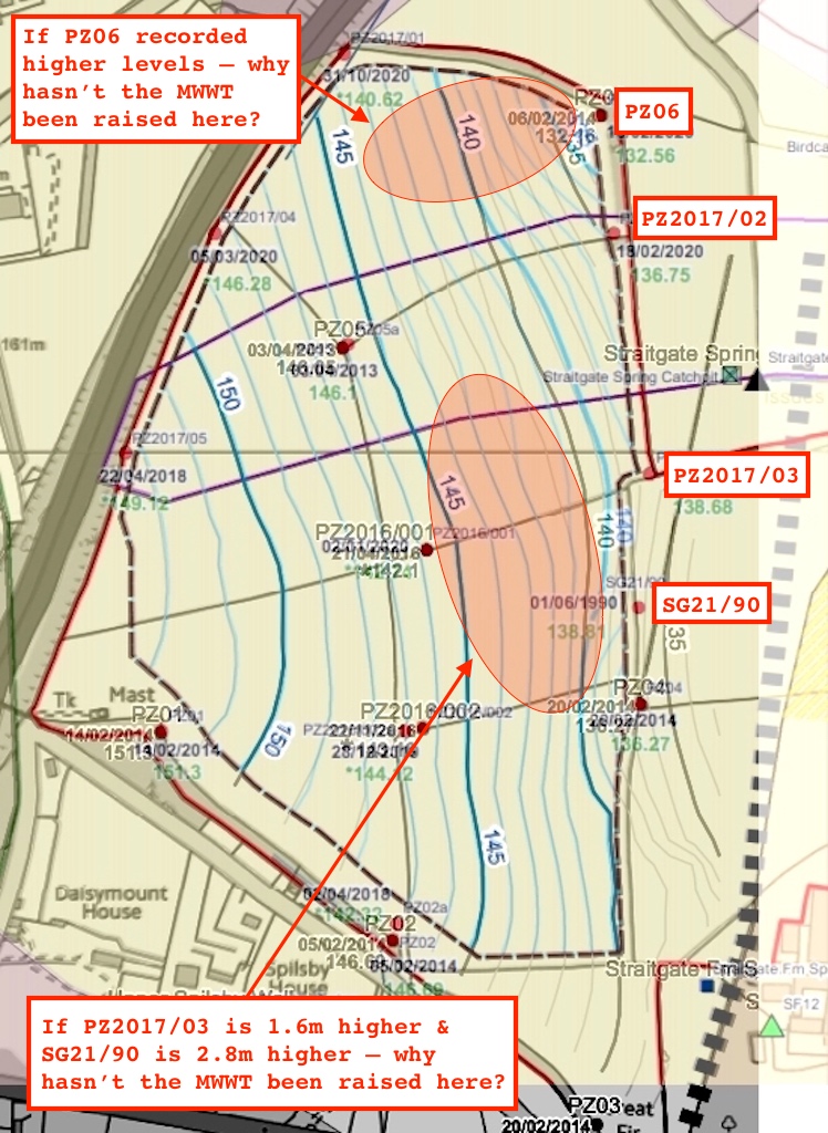
Based on further information received from SAG we recommended to Devon County Council that the applicant updates the Maximum Winter Water Table grid with groundwater levels recorded at the site in 1990. 
Aggregate Industries’ consultants subsequently produced a revised MWWT to accommodate groundwater levels recorded in borehole SG21/90 (also known as SG1990/021). 

But crucially, those 1990 groundwater levels were recorded in summer. The MWWT at location SG21/90 therefore now reflects a summer level. The MWWT and the summer level at SG21/90 are one and the same; the difference is ZERO. Clearly, groundwater levels do not fall by 1m from the MWWT here in the summer. Only by adding 1m to the MWWT in this area could Aggregate Industries' seasonal scheme even begin to work as described.

Appendix C – referred to above, shown below – and its Himalayan-style contours "of average summer unsaturated mineral thickness" is one of the documents Aggregate Industries is relying upon for its planning application.

  
We have already posted that it contains errors the height of houses. That was before the Environment Agency recommended the MWWT be updated using 1990 data. What that means is that around SG21/90 there is not 4m of summer unsaturated thickness as shown above, and here, there is in fact ZERO.

Given that those lines of fiction were interpolated, this figure will obviously have a knock-on effect on the surrounding area, and on the amount of resource available. Obviously, extraction down to the MWWT would never be possible – if planning conditions were complied with – in areas where the groundwater does not fall by 1m in summer.

Lines of fiction? Not only were those amazing patterns derived from just a handful of data points, but in some areas those claimed "contours of average summer unsaturated mineral thickness" even exceed the depth of mineral between the MWWT and underlying mudstone. Sense-checking is not Aggregate Industries' strongest suit.

But it doesn’t stop there, because those Himalayan contours above were generated in July 2017. At that time, only 8 piezometers had been recording groundwater levels for longer than 12 months. The above contours have therefore NOT been updated by the summer groundwater levels recorded over the almost 4 years since then – not just from those 8 piezometers, but also from piezometers PZ2017/01, PZ2017/02, PZ2017/03, PZ2017/04 and PZ2017/05 installed in 2017. 

Neither have those contours been updated using the summer 1990 levels. 

Without using ALL the available summer groundwater data for the site, without using maximum summer groundwater levels, no-one can know what might be revealed, no-one can make an informed decision. 

As things stand, therefore, the Environment Agency's condition could not be met: there would not always be 1m or more of unsaturated material below the level where Aggregate Industries would be working. It's yet another fail.

Wednesday 9 June 2021

EDDC approves AI’s application for cattle crossing – with conditions


It may have been a hollow victory for the company though, given that Condition 6 – "The access shall not be used for any additional livestock movements" – would not permit the current dairy herd to use the new access more than a few times a year. 

Aggregate Industries’ representative spoke at the meeting, claiming: 
The farm tenants, via their agent, had informed the company of their requirements to move the dairy herd and other livestock, more particularly described in the application document at paragraph 1.7 of the supporting statement, across the Exeter Road to access other grazing land to the south owned by the tenants’ family.
In other words, it was all the tenants’ idea, the company was doing them a favour. Yeah, right. 

The truth is that only when it became clear that a quarry at Straitgate Farm would remove almost 90% of the grazing land on the north side of the road were Devon County Council informed that the dairy herd would need to regularly cross the B3174 Exeter Road to access replacement pasture. Aggregate Industries submitted the planning application for a new field access and holding pens following advice from Devon County Council

Where do we stand now? Nothing has changed. The farm's dairy herd would still need to access replacement pasture on the south side of the road should a quarry proceed. Does this application put any restriction on future movements elsewhere? Of course not. As we’ve posted before
 ... neither Aggregate Industries nor Devon County Council can tell the farmer how to run their business. There are no laws preventing farmers herding livestock across or along roads. The highway authority has no explicit powers to prevent a farmer doing so. As long as it's done safely, with crossing points washed down, if the farmer needs to put cows across the road to sustain their business then they can do so. It happens all over Devon. 
Cllr Key echoed the very same thing at the meeting today:
In actual fact, if somebody wanted, they could walk cattle from one end of that road to the other, and nobody could stop them, so long as they’ve got somebody in front and somebody behind, there’s no way at all that anybody could stop them, and they could take all day to do it.

‘All mineral development will need to comply with the plan’

Not our words, but those of Devon County Council in 2017: 

As Cllr Jerry Brook – chairman of the same committee that will determine Aggregate Industries’ planning application to quarry Straitgate Farm – acknowledges, and as we all know, "years of hard work went in to preparing and consulting" on the Devon Minerals Plan to provide "the policy framework for mineral development in the county" over the period to 2033. 

The "All mineral development will need to comply..." statement in the press release appeared earlier at the Development Management Committee 15 July 2015 when members were asked to endorse the Pre-submission Draft Minerals Plan: 
The Devon Minerals Plan therefore proposes a vision for sustainable mineral development and provides a range of policies to achieve this goal. The Plan emphasises the need to conserve mineral resources for future generations and to make best use of the waste generated by mineral and construction activity, while acknowledging that, for some resources, working will need to extend into new areas. All mineral development will need to comply with a set of policies addressing their impacts to minimise harm and boost positive outcomes
If that last sentence had been replaced with: 
Some mineral development will need to comply with some policies… 
or:
Mineral development will only need to comply with those policies that do not impede the operations of mineral companies, even if ignoring some policies would cause harm and negative outcomes... 
how would councillors have voted then? 

What policies are we talking about? Policies such as this:
The transportation of extracted materials for processing elsewhere should meet the requirements of Objective 1 and Policy M22 for minimal transportation by road. 
Now it looks like DCC is wanting to forget all about policies – in order to facilitate the destruction of East Devon farmland, mayhem on Ottery's main road, and millions of miles of polluting HGV haulage. In which case, local people will rightly wonder what all the "years of hard work" were for, if – when the first greenfield quarry application comes before it – so many of the policies contained within DCC's expensive new Minerals Plan stand for nothing. And if the policies stand for nothing, and the Council has its own agenda, people will also question the point of responding to DCC's various consultations... and will most likely conclude none at all.  
Has anything changed since then? 

Of course, one policy relevant to Straitgate that was junked after that meeting in 2015 was the one that would have maintained a 1m unquarried buffer above the maximum water table to protect drinking water supplies. "Table C.4: Constraints and Mitigation Measures for Straitgate Farm" once read: 
The development of this site will only involve dry working, above the maximum winter (wet) level of groundwater with an unsaturated zone of at least 1m maintained across the site.
How many more policies are to be cast aside to appease Aggregate Industries?

More greenwash from Aggregate Industries

Apparently, Aggregate Industries’ commitment to sustainability runs right through its business:


If we overlook the fact that Aggregate Industries might be confused – that World Environment Day is the United Nations' way of encouraging us to protect the environment, not to continue digging it up and exploiting it – how has this "commitment to #sustainability" informed the company's application to quarry Straitgate? Anyone? Pray tell, Aggregate Industries, because local people will be scratching their heads. 

It certainly isn’t the 2.5 million mile haulage scheme. It certainly isn’t the permanent harm to drinking water supplies to people, heritage assets, ancient woodland and livestock farms – as starkly set out by Professor Brassington. It certainly isn’t the increased risk of flooding – prompting an objection from the County Council's Flood Risk Team. It certainly isn’t the loss of best and most versatile farmland, or ancient hedgerows – habitat for dormice and bats. It certainly isn't any of these issues.

The dictionary defines greenwash as: "to make people believe that your company is doing more to protect the environment than it really is." Essentially, it "refers to dishonest or deceitful marketing about a company or product’s environmental impact."  

As for "the ethics we adopt", don't get us started. Examples of those ethics have been well and truly documented over the years on this very blog: the bully-boy tactics, the dangerous HGV antics, the gagging of a journalist, the stopping of public scrutiny of groundwater data, the blocking of a community's social media account, the sort of company that prompts a council to say "Arrogance of Company; no local consultation; contempt for local community...".

Wednesday 2 June 2021

So – after the latest consultation – where do we stand now?

In 2015, Aggregate Industries' documents supporting its application to quarry Straitgate Farm explained: 
The need for new mineral reserves is a material consideration which is to be balanced against the assessment of the acceptability (in terms of environmental harm) of the proposed development (often referred to as the planning balance).
The company advised decision makers that the planning balance was "weighted in favour of a positive determination". Well it would, wouldn’t it? 
The [Environmental Statement] demonstrates that there would be no unacceptable adverse impacts on the natural and historic environment, local amenity or human health... It has not identified any instances where planning policy is not complied with, and the planning balance is therefore weighted in favour of a positive determination..
Despite the bravado, it transpired that Aggregate Industries got nowhere near determination, either positive or negative. The company could not demonstrate the "exceptional circumstances" demanded by the NPPF for continuing to process material in an AONB, and did not have the necessary rights to use 3rd party land for site access. The application was withdrawn.  

That weighting in favour of positive determination in 2015 was when the stated benefit was touted as 1.66 million saleable tonnes, when material was to be processed 7 miles away on Woodbury Common – apparently because "processing the Straitgate deposit at Blackhill Quarry is the only practical solution..." – and when the company erroneously claimed "an ongoing need for 0.8 million tonnes per year to meet current, established demand."

What have we learnt since 2015?
  • that as-dug material would now have to be transported 23 miles to Hillhead near Uffculme for processing – a site that already has more than 2 million tonnes of permitted sand and gravel reserves with a further 23 million tonnes of resource nearby; such an unsustainable scheme would be contrary to Objective 1 of the Devon Minerals Plan; Aggregate Industries’ attempt to show this would be the most sustainable option is fundamentally flawed; 
  • that the surface drainage plans, so crucial for groundwater recharge, stream flows, flooding prevention and airport safeguarding could not work; groundwater levels are too high to allow level 3m deep infiltration trenches to be dug without breaching the MWWT; post extraction drainage would not mimic the existing site as the Environment Agency has conditioned; more water would be directed in some directions, including towards a 300mm culvert, and less in others; elevated groundwater levels have not informed the 2016 Flood Risk Assessment; the Council's Flood Risk Management Team has raised a raft of other concerns and has now objected twice; 
  • that removal of the unsaturated layer would, according to Professor Brassington, result in a permanent change to groundwater chemistry making it forever more acidic for 100 people, Grade I listed Cadhay and its mediaeval fishponds, wetland habitats in ancient woodland, and livestock farms; 
  • that the MWWT turned out to be a hand-drawn guesstimate, not a reliable model of the maximum groundwater levels at all, having been exceeded on numerous occasions; 
  • that the company plans to quarry down to the MWWT, removing all of the unsaturated zone, not leaving the normal buffer, making no allowance for errors, no allowance for climate change, no allowance for an unorthodox working scheme not used anywhere else in the country; 
  • that the Section 106, supposed to offer protection to surrounding water users, does nothing of the sort according to legal experts; that the detail of alternative supplies has neither been provided nor assessed; 
  • that cattle would as a result need to cross the B3174 Exeter Road up to 4x daily for replacement pasture; the impact of these crossings, together with up to 216 HGV movements, has not been assessed either on safety or the functioning of the B3174 and the A30; 
  • that, according to Natural England, there are still concerns over soil management; 
  • that the Birdcage Lane site access would increase the risks to school children, and potentially cause criminal damage to 3rd party property; 
  • that Aggregate Industries’ confusion of out-of-date documents are riddled with faults and contradictions; many working drawings conflict with other working drawings.
To name but a few. Has any of this been resolved? No. 

And the stated benefit now? Reduced by 36% or 600,000 tonnes to 1.06 million tonnes – and that is before the further cuts that would be needed to accommodate a working drainage scheme, and the further cuts that typically happen once Aggregate Industries starts digging

And the ongoing need now? Some 37% less than the company claimed in 2015, with the 10 year sales average standing at 0.5 million tonnes.

So, if the planning balance was previously "weighted in favour of a positive determination" before discovering the litany of problems listed above, and before the 36% cut to the benefit, where’s the balance now Aggregate Industries? 

No wonder the company will this month start drilling boreholes at Penslade – the 23 million tonne sand and gravel resource next door to its Hillhead processing plant – "to enable the monitoring of the watertable as required by the Devon Minerals Local Plan."

Fracture flow? What fracture flow?


Straitgate Farm is underlain by the Budleigh Salterton Pebble Beds deposit, now called the Chester Formation, part of the Sherwood Sandstone aquifer. The deposit can be seen in the cliffs at Budleigh Salterton – as shown above, below and here.


Aggregate Industries and consultants Wood, previously Amec Foster Wheeler, maintain – as we have previously posted – that at Straitgate:  
...recharge reaches the water table in the BSPB through unsaturated thicknesses of between approximately 3 and 10 m within between 1 and 3 days. 
However, there was a time when Aggregate Industries was arguing the reverse – when the debate was about the risk of importing nutrient-laden soils to Woodbury Common. The company was claiming the soils at Straitgate Farm were "slowly permeable and at times poorly drained": 
This would strongly inhibit the movement of any nutrients added to the surface, either as artificial fertilisers or manure, through the soil profile and into the deeper overburden and mineral resource that would be exported off site for processing. 
This is still in fact echoed in the soils report which also talks about "slowly permeable subsoils". The infiltration tests also found that the undisturbed material "did not show any measurable ability to soakaway". At that time, it wasn’t the answer Aggregate Industries was looking for, and so the company concluded – surprise, surprise – that "these results cannot be considered to be representative of the site as a whole." 

Water speeding through the unsaturated zone "within between 1 and 3 days" is in contradiction with what the textbooks say. Professor Brassington explains how movement of water through the unsaturated zone at Straitgate takes years, and that the loss of this unsaturated zone would make water permanently more acidic for all those who depend upon it. 


How do Aggregate Industries’ consultants explain this rapid movement through the unsaturated zone, and therefore the apparent benign effect on groundwater chemistry from its removal? In part because of fractures. In three different documents it is written:
2.7.2 ...recharge to the BSPB was best represented as a single quick release number, independent of unsaturated depth because of its more fractured nature etc 
2.5 ...transit of water through the unsaturated zone is considered to be fairly rapid due to the intergrannular and fractured nature of the BSPB and therefore the thickness of the unsaturated zone may not be as important. 
3.7.2 The proposed quarry at Straitgate Farm is located on the outcrop of the BSPB in which intergranular flow predominates but an element of fracture flow may also be present as evidenced by the quick response, and subsequent decline, of groundwater levels in PZ02 and PZ06 following heavy rainfall events. 
The problem with fracture flow? Prof Brassington says there are no fractures at Straitgate
There is no evidence that the unsaturated zone (nor any other part of this aquifer) is fractured. The lack of cement means that the rock cannot be fractured as the adjacent uncemented particles would fall into any fractures present. The measurements carried out that led to this conclusion are not based on any published methodology and I believe them to be misleading.  
 

How can we be sure the deposit is not cemented? Easy. It’s why Aggregate Industries is drawn to the deposit in the first place. As Prof Brassington explains: 
The Chester Formation at Straitgate is not cemented which is why it is attractive to a quarrying company as it can be dug with excavators and does not require any explosives. Because of the lack of cement the presence of fractures or fissures are unlikely in the extreme.
This BGS document explains further: 
3.1.3 In the south of the study area, the Budleigh Salterton Pebble Beds Formation forms the top of a 160 m high ridge of heath land, distinct from the Otter Sandstone Formation by the elevation and vegetation type (see Figure 2.2) (Ussher et al., 1913; Walton, 1982). South of Uffculme the nature of the formation changes considerably. Locally derived limestone clasts are replaced by quartzite, and the formation becomes unconsolidated and uncemented (Allen et al., 1997; Walton, 1982). In the south the formation consists of brown gravel with subordinate beds of sand. The gravel comprises well-rounded pebbles, cobbles and boulders contained within a coarse to fine gravel and a silty sand matrix. Up to 90% of the clasts are metaquartzite with some composed of porphyry, vein quartz, tourmaline and feldspathic conglomerate (Edwards, 1997). There is a lack of carbonate cement, and only localised patches of iron minerals are found. This southern portion of the Budleigh Salterton Pebble Beds Formation has therefore been worked for aggregates over the years. 
And the strange thing? In their response to Prof Brassington in September 2019, Aggregate Industries' consultants don’t dispute that the deposit is uncemented: 
The BSPB comprise largely unconsolidated uncemented gravel and sand. 
Nevertheless, Wood still continue to argue for the presence of fractures/fissures in an attempt to explain why the speed of water percolating through the unsaturated zone is not in the range of 0.6 – 2.3 metres per year put forward by Prof Brassington: 
The range of 1 to 2 metres per year has been given as an ‘average’ and, hence, could be considerably faster at Straitgate. The poorly cemented nature of the BSPB at Straitgate, along with its high content of relatively coarse material and evidence of recharge via fractures/fissures seen in some piezometers on site suggest that the rate of percolation will be higher than this average range. 
No robust evidence has ever been provided to support Wood's claims that it "could be considerably faster." Tests have been done, here and here. None have been conclusive. Here was one attempt: 
2.7.5 As discussed with the EA on 24 May 2017 the opportunity was taken during the drilling of the replacement and new piezometers to undertake some semi-qualitative testing of the unsaturated zone. A version of a falling head test (slug test) was undertaken. The details and results are included in Appendix E. The conclusions are: Seven infiltration tests were carried out in five test boreholes at Straitgate Farm targeting the unsaturated zone of the BSPB formation, below the cryoturbated overburden. Water was introduced to the boreholes via a pipe to the base of the hole and the time it took the water to infiltrate into the BSPB was recorded. The majority of boreholes were affected by collapse to varying degrees throughout the tests, indicating that the BSPB is unconsolidated and loosely cemented which often suggests a high degree of permeability… Although these results can only be considered as semi-quantitative the results are consistent with the conceptual model for relatively rapid recharge occurring in the BSPB (i.e. days rather than weeks or months). 
But whether the tests were semi-qualitative or semi-quantitative, whether the hosepipe was green or orange, Prof Brassington dismisses them
They also used boreholes to make tests that were unique, and although I have searched, I cannot find any reference to this method in the literature. In my view, these tests would not provide any quantified description of the unsaturated zone flow regime.
Indeed, the fact that the "majority of boreholes were affected by collapse" would seem to back up Prof Brassington’s assertion that there would be no fracture flow because "uncemented particles would fall into any fractures present." 


Fortunately we know what the resource at Straitgate Farm looks like. Trial pits some 6-7m deep were dug in 2012 to analyse the resource. We were there. Both we and Aggregate Industries took photos.
In Amec Foster Wheeler (2017b) a series of photographs are published of the trial pits that were excavated to examine the presence of a clay layer across the site. These pits are to 6-7 m depth and the photographs appear to be good quality. I have examined them most carefully and find no evidence for any fractures or fissures. I conclude that there is no direct physical evidence for the existence of a fracture network at Straitgate Farm; indeed the uncemented strata provides some geological evidence that no such fractures exist, as fractures would depend on the rock through which they penetrate not to collapse so that they remain open. 
And who can disagree with that? Perhaps Aggregate Industries’ consultants Wood haven’t quite made up their minds yet. Having told the Environment Agency and the rest of us about the "fractured nature of the BSPB", Wood has now conceded – at the recent Hydrogeology Meeting – that fractures "can’t be totally discounted". 

So, who to believe? Consultants, bankrolled by a company determined to dig up the aquifer so important for people’s drinking water supplies, who perhaps haven't quite made up their minds yet? Or the Professor who writes textbooks on the subject? The answer should be very easy.