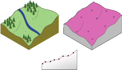
The Environment Agency's letter of 9 October to DCC was very clear. Amongst other things, the Agency wanted Aggregate Industries to provide information on tolerances; specifically:
A description of the tolerance levels and interpolation method used to produce the ‘Maximum Winter Water Table’ grid.
Why? The MWWT is the surface that AI wants to quarry down to at Straitgate Farm. It would be the floor to any quarry. As AI does not intend to leave 1m unquarried above the MWWT to protect drinking water supplies - the typical requirement elsewhere - it is quite appropriate to ask what level of confidence AI or its consultants Amec have in this surface, and how this tolerance level has been derived. When essentially only 6 data points have been used to model this surface across almost 60 acres, the MWWT obviously cannot be exact. So, is it +/-1m, +/-2m or more? It's important to know because it could have a dramatic bearing on any working method employed.
As we posted last week, AI has now responded to the EA’s recent letter - at least in part. But whilst Amec is happy to talk about interpolation methods - it still won't address tolerances.
It’s almost two years ago that we first asked DCC the question:
Since AI now intends to dig right down to the maximum water table, perhaps you could ask Amec to confirm the specific level of accuracy (in +/- m) to which their maximum groundwater contours are mapped?
DCC asked AI and Amec for an answer. No answer was forthcoming. The EA’s letter effectively asked the same question again. Still no answer was forthcoming.
With the maximum groundwater contours defining the extent of any quarrying this is obviously a critical point - with so many people relying on the area’s groundwater for their drinking water supplies; relying on their wells not drying up or becoming polluted.
Interpolation, in this case at least, is just a fancy word for estimation. Amec's response says "Four alternative grid interpolation methods were selected... Each of these methods represents an exact interpolator". Perhaps Amec hoped that the word "exact" might deal with the issue. It doesn’t.
What an "exact interpolator" means here is that the estimated MWWT surface passes through each of the six recorded maximum water level points. In other words, the MWWT surface is "exact" in just 6 locations. It does not mean that the interpolation is "exact" anywhere else across the site. No surface modelled across 60 acres from 6 data points could be.
And to demonstrate just that, it turns out that two of those four mathematical interpolation methods "selected" didn’t work. And even for the method chosen, Radial Basis Function:
RBFs are conceptually similar to fitting a rubber membrane through the measured sample values while minimizing the total curvature of the surface. The basis function you select determines how the rubber membrane will fit between the values.
RBFs are used to produce smooth surfaces from a large number of data points.
Amec cannot claim the entire surface is exact, that the error is zero, that the tolerance is +/-0m, because:
In this case the data samples - all 6 of them - are not "dense", far far from it.
So Amec has chosen to stay silent again - even to the EA. What have AI and Amec got to hide? And how much confidence is that going to give local people?
