Does any part of Aggregate Industries' planning application to quarry Straitgate Farm make sense? Even the restoration plan has problems.
The company claims "the restored landform will be designed so that drainage reasonably mimics the current condition":
5.3.3 The excavation is designed to include areas of infiltration that will be sized to capture all runoff from the workings and infiltration areas will be incorporated into the final restoration design. This will be designed to enhance groundwater recharge and will increase infiltration and spring flows by the amount of overland flow that would otherwise have occurred.
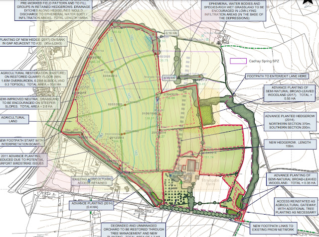
In 2013, the Environment Agency delineated a Source Protection Zone in an effort to protect Cadhay's water supplies. The above plan overlays the SPZ and maximum water table contours – the base of any quarry – over the restoration plan.
In 2017, in its Regulation 22 request, the Council requested information on the infiltration areas:
3.6 The MPA has insufficient information about the management of the infiltration/ephemeral pond area to determine whether it will contribute to the appropriate management of surface and groundwater flows; stream recharging; airport safeguarding and long term agricultural restoration.
Two proposed ephemeral water bodies in the low-lying infiltration areas are shown as part of the Straitgate Farm restoration scheme on Drawing SF/6 (Rev.A). The proposed restoration scheme ensures that post-extraction the site will be returned to a similar baseline condition. The proposed enhanced infiltration areas for the Birdcage and Cadhay Wood sub-catchments are not SuDS and as they are infiltration areas they will not be permanent waterbodies. They are simply a feature incorporated into the restored landscape to assist in providing some betterment over the baseline conditions. These will be formed to enhance the capture of ‘overland flow’ and to locally increase the proportion of rainfall that passes to groundwater.
But if the restored landform is to mimic current drainage, why on earth is one of these enhanced infiltration areas – areas designed to "to locally increase the proportion of rainfall that passes to groundwater" – located outside of the area that feeds Cadhay’s spring, drawing water away from a crucial water source for a Grade I listed house?
