Aggregate Industries' model of the maximum winter water table – the MWWT, denoted by the contours below – would define the base of any quarry at Straitgate Farm.
Professor Brassington says it can’t be trusted. We have already shown that the MWWT is nothing more than a hand-drawn guesstimate. The MWWT makes no allowance for errors, no allowance for climate change, no allowance for an unorthodox working scheme not used anywhere else. It may give the illusion of being precise, but time has demonstrated it is anything but.
To indicate this, let's show what journey these contours have been on. Let's superimpose Aggregate Industries' first stab at estimating groundwater levels in 2013 over the latest MWWT.

In places, the latest MWWT – in blue – is now 5m higher than that initial 2013 estimate. How very fortunate that estimate wasn’t used. The next guesstimate in 2015 was based on levels which we were told "are likely to reflect the highest groundwater levels that may occur at Straitgate". These levels have since been exceeded in numerous locations on numerous occasions. As we recently posted:
The maximum water level in PZ2017/02, which exceeded the MWWT back in 2018, went nearly 50cm higher in 2020. The groundwater level in this location has now exceeded the company's original guess by a whopping 1.75m. Water levels in PZ06 – installed back in 2013 – also reached a new maximum, as did three other piezometers.
In time, the MWWT will be exceeded again. A maximum is not a maximum if it keeps being exceeded.
The latest MWWT is found in the recently submitted document Collation of post Regulation 22 discussions and clarifications, which says:
...as requested by DCC, this document includes a revised version of the Maximum Winter Water Table (MWWT) grid which incorporates any recently recorded groundwater water levels higher than the previous MMWT (including ‘spot’ groundwater level measurements recorded in 1990).
The revised MWWT is included in this pack of correspondence and includes additional adjustment for slightly higher groundwater levels recorded close to the eastern boundary (PZ06, 2017/02 and 2017/03) in April 2018 and February 2020. The following are noted from the revised MWWT: The method used for determining the MWWT is slightly conservative and means that the extent to which the grid is raised propagates from the eastern boundary to the centre of the excavation area. In reality, the higher recorded groundwater levels most likely represent more localized effects close to the eastern boundary.
But knowing these contours are drawn by hand – a potentially biased and persuadable hand, not some clever computer algorithm – let's look at the revised MWWT against the previous version. Let’s see what allowance Aggregate Industries’ consultants have made for the elevated water levels recorded on the eastern boundary. Superimposing the new MWWT over the previous MWWT – blue for new, grey for previous – this is what we find:
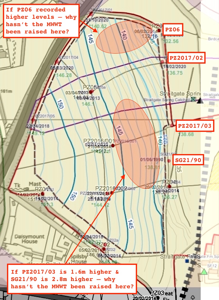
It's immediately clear "that the extent to which the grid is raised" is minor.
It's also clear that, far from being "slightly conservative", the MWWT should in fact be raised more widely – given the elevated levels recorded at PZ06, PZ2017/02, PZ2017/03 and SG21/90, given that the MWWT is an interpolated surface, and given the lack of any other contradictory data in the vicinity of these piezometers to demonstrate otherwise. The Environment Agency's proposed conditions state:
If any of the maximum recorded groundwater levels exceed the height of the MWWT grid then the MWWT grid shall be updated using that data...
Continuous (daily) monitoring of all site piezometers, and interpolation between them, shall be used...
Our emphasis. So – in the areas indicated – what's happened to the interpolation? In fact, why was the entire MWWT not re-interpolated, in the same way it would have been had all these new maximums been available in 2015? Why have we instead been left with a tweak, an "adjustment", a fudge?
Note that when Aggregate Industries’ consultants talk about "slightly higher groundwater levels" we’re talking about 1.6m in one location, 1.75m in another and 2.8m in another – so not slightly at all.
Note that when Aggregate Industries’ consultants talk about "most likely more localized effects close to the eastern boundary", they don’t have a watery clue – given the lack of other boreholes between the eastern boundary and the centre of the site.
So, why has the MWWT not been raised more extensively, based on all the data, based on reason and logic? Easy. These consultants are trying to wrestle from the ground as much material as possible for their paymasters – irrespective of the permanent harm it would cause to surrounding water supplies.