The depth of proposed extraction is one of the most critical pieces of information for any quarry planning application. Why? Because it determines how much resource can be wrestled from the earth, and how much damage will be caused to the surrounding water regime in the process.
Surely by now, three years on from the company’s first planning application, Aggregate Industries should know how deep it could safely dig at Straitgate Farm? You would have thought so, but no – not judging by
the latest groundwater monitoring data.
AI has claimed –
contrary to warnings from other hydrogeologists – that it’s safe to dig down to the maximum winter water table, but
after five years of groundwater monitoring and 18 boreholes it’s clear that the company still hasn’t discovered exactly where that level is.
Determining the MWWT is important because AI plans to work Straitgate dry. It needs to do this to protect surrounding springs, streams and drinking water supplies.
We’ve always said that AI can’t model this MWWT with any sort of accuracy – except at the locations measured. That’s why standardly 1m is left unquarried as a buffer to protect water supplies; a 1m buffer that AI has decided local people can do without, so it can bank the profits instead.
Consultants Amec (now Wood) claimed the MWWT had been "defined with confidence" but were
reluctant to say how confident, in +/- m terms. Now we know why. Because the model – which it was claimed "builds in a conservatism" – has already failed, and AI’s seasonal working scheme has been exposed for what it is – a shambles.
But it’s worse than that. AI has now supplied us with groundwater monitoring data for Straitgate for the last quarter – and for the first time it came with a commentary, presumably from Wood:
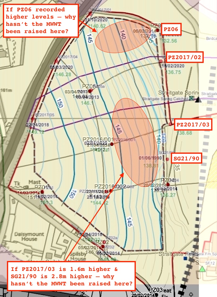
Turning to the attached spreadsheet; you will see from the most recent data (Feb-April 2018) that groundwater levels in two of the newer piezometers installed in 2017 (PZ2017/02 and PZ2017/03) have shown higher groundwater levels than expected this winter. Groundwater levels in all other piezometers across the site have levels as expected and have remained lower than the gridded maximum winter water table, so this is thought to be a localised effect in an area where data was limited prior to the installation of the 2017 piezometers.
There could be a number of reasons for the higher than expected groundwater levels in this location such as:
* localised effects caused by temporary backing up behind the BGS fault (where BSPB is faulted against BSPB) which could be of lower permeability (reduction in transmissivity) than envisaged or positioned further west than mapped.
* localised clayey horizons giving rise to confined/semi-confined conditions.
In other words:
Whoops. We’ve got things wrong. We don’t really know why. We have a number of ideas. We hope the problem is localised but without drilling more boreholes we’re just guessing. We say it’s just these two points - but to tell you the truth, we haven’t properly checked the others yet. We’re now not even sure where the BGS fault is.
Hardly instills confidence does it?
How much 'higher than expected' has the groundwater risen in these two locations?
In February, we posted that groundwater levels at PZ2017/02 and PZ2017/03 had reached 134.62m and 138.06m, compared with the modelled MWWT in these locations of 135m and 137m respectively.
The latest data shows these levels have now risen further, and on 3/4 and 10/4/18 reached 136.28m and 138.57m – a difference compared with AI’s MWWT model of 1.3m and 1.6m respectively.
But it’s worse than that. The surface elevation at these positions is 138m and 139m AOD respectively.
There is therefore
NO winnable sand and gravel from this area or from the – as yet undetermined – surrounding area. Even
plans in 1967 recognised that much.
But it’s worse than that. Even overlooking the 1967 plans, AI has had 12 months warning about all this. PZ2017/03 is next to "Test Hole 4". We posted on this subject last year, how in June 2017
‘Drillers were really surprised they struck water so quickly’. Given that in April this year, groundwater at this location reached less than 0.5m below ground level (139 - 138.57), it’s not so surprising now.
But it’s worse than that. Two other locations, PZ06 and PZ05a, also exceeded the MWWT model with new maximums of 132.43m and 146.78m reached on 15/3/18. On PZ05a, AI’s consultants hope that:
Water level thought to be below borehole screen and within sump as indicated by 'flatline' hydrograph. Hydrograph not representative of BSPB [groundwater levels]
But thinking so and knowing so is quite different. In any case, PZ05 in the same location has been flatlining for 5 years now. Was that not "representative" either? Does anyone trust these consultants to recognise "representative" groundwater levels based on previous errors?
So, Wood’s assertion that "Groundwater levels in all other piezometers across the site have levels as expected and have remained lower than the gridded maximum winter water table" is obviously incorrect.
But it’s worse than that. These elevated groundwater levels this year were
not reached during a particularly wet winter and spring, according to
Met Office data, and nothing like the winter of 2014 when the other ‘maximum’ groundwater levels were recorded elsewhere across the site. In fact, in the South West, total rainfall in the
winter and spring of 2014 was 35% higher than the same period in 2018. These maps put things in perspective:
Any piezometer installed after 2014 (7 out of the 18) is therefore unlikely to have yet logged a maximum.
But it’s worse than that. These problems occur in and around the Environment Agency’s Source Protection Zone for the water supply for Grade I Cadhay. Furthermore, these elevated levels have plainly only been recorded where boreholes have actually been drilled. For all AI, Wood, or anybody else knows, they could be higher elsewhere. This is why – with more than 100 people reliant on the site for drinking water – precaution should obviously prevail.
It’s all a giant mess. How prescient hydrogeologist Dr Rutter was when she warned that at Straitgate:
Because errors are what we’ve got. And without many more boreholes and many more years of monitoring to give a fuller picture of what’s going on at Straitgate, errors are what we will keep on getting.
Who knows, if AI hadn’t been greedy for the last 1m of gravel above the MWWT perhaps none of the above problems would have been revealed? But then we could have been staring at large lagoons of water – and associated birdlife – directly under the flight path of Exeter Airport. We could have been staring at flooding downstream in Ottery St Mary. We could have been staring at all sorts of problems with surrounding water supplies. It doesn’t bear thinking about.
AI and its band of partisan consultants will now have to go back to their drawing boards and get their facts right, or, with the resource reduced still further, give it all up as a bad job.